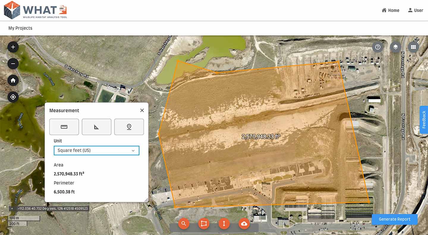
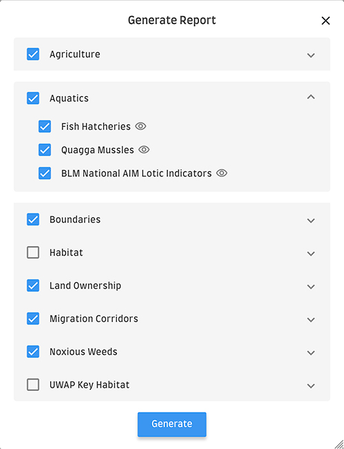
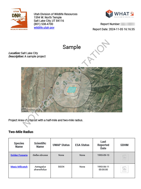
≡
Utah Species Field Guide
Welcome to the Field Guide for Utah Species, a database maintained by the Utah Natural Heritage Program. This guide is not intended to be a comprehensive list of all species found in Utah, and currently prioritizes our state's 256 native species of greatest conservation need as identified in Utah's Wildlife Action Plan.
This guide provides information on the identification, distribution, status and ecology of Utah's most at-risk animals and plants. As time and funding allow, this database will include all native Utah species.
To find a specific species, enter it in the search bar or use the breadcrumb menu below.
Search by word or phrase
Search by hierarchy
Animals (Animalia)
Multicellular organisms that develop from the fertilization of an egg by a sperm. Heterotrophic - obtain food by ingestion.
Vertebrates (Craniata)
Have skulls and backbones.
Birds (Aves)
Have feathers and lay eggs
Hawks / Kites / Eagles (Accipitriformes)
Hawks / Kites / Eagles (Accipitridae)
Vultures / Condors (Cathartiformes)
Vultures / Condors (Cathartidae)
Shorebirds (Charadriiformes)
Avocets (Recurvirostridae)
Sandpipers (Scolopacidae)
Plovers (Charadriidae)
Cuckoos (Cuculiformes)
Cuckoos (Cuculidae)
Upland Game Birds (Galliformes)
Upland Game Birds (Phasianidae)
Songbirds (Passeriformes)
Flycatchers (Tyrannidae)
Thrashers / Mockingbirds / Catbirds (Mimidae)
Finches (Fringillidae)
New World Sparrows (Passerellidae)
Jays / Crows / Magpies (Corvidae)
Pelicans / Herons / Bitterns / Ibises (Pelecaniformes)
Ibises (Threskiornithidae)
Pelicans (Pelecanidae)
Woodpeckers (Piciformes)
Woodpeckers (Picidae)
Owls (Strigiformes)
Amphibians (Amphibia)
Cold blooded, moist skin
Frogs / Toads (Anura)
True Toads (Bufonidae)
True Frogs (Ranidae)
Mammals (Mammalia)
Have hair, feed young milk, warm blooded.
Carnivores (Carnivora)
Weasels (Mustelidae)
Wolves / Coyotes / Foxes (Canidae)
Bats (Chiroptera)
Bats (Vespertilionidae)
Rabbits / Hares (Lagomorpha)
Pikas (Ochotonidae)
Rabbits (Leporidae)
Rodents (Rodentia)
Pocket Mice / Kangaroo Rats (Heteromyidae)
Squirrels (Sciuridae)
Fish (Actinopterygii)
Use gills to breathe
Minnows / Suckers (Cypriniformes)
Leuciscidae
Northern Leatherside (Lepidomeda copei)
Least Chub (Iotichthys phlegethontis)
Woundfin (Plagopterus argentissimus)
Colorado Pikeminnow (Ptychocheilus lucius)
Virgin Spinedace (Lepidomeda mollispinis)
Virgin River Chub (Gila seminuda)
Suckers (Catostomidae)
Perch / Sticklebacks (Perciformes)
Sculpins (Cottidae)
Salmon / Trout (Salmoniformes)
Reptiles (Reptilia)
Cold blooded, lay eggs on land
Lizards / Snakes (Squamata)
Colubrid Snakes (Colubridae)
Vipers (Viperidae)
Helodermatidae
Turtles (Chelonia)
Testudines
Tortoises (Testudinidae)
Mollusks (Mollusca)
Soft bodied animals with an internal or external shell and a toothed tongue or radula. Have a mantle that lines and secretes the shell and a muscular foot that allows for movement.
Snails / Slugs (Gastropoda)
Usually have chambered shells.
Aquatic Snails (Basommatophora)
Fossarias / Pondsnails / Lanxs (Lymnaeidae)
[No Common Name] (Galba techella)
Fat-whorled Pondsnail (Stagnicola bonnevillensis)
Wrinkled Marshsnail (Stagnicola caperata)
Physas (Physidae)
Sprites / Gyros / Rams-horns (Planorbidae)
Littorinimorpha
Amnicolas / Duskysnails (Hydrobiidae)
Bear Lake Springsnail (Pyrgulopsis pilsbryana)
Otter Creek Pyrg (Pyrgulopsis fusca)
Bifid Duct Pyrg (Pyrgulopsis peculiaris)
Nuwuvi Pyrg (Pyrgulopsis nuwuvi)
Carinate Glenwood Pyrg (Pyrgulopsis inopinata)
Desert Springsnail (Pyrgulopsis deserta)
Black Canyon Pyrg (Pyrgulopsis plicata)
Smooth Glenwood Pyrg (Pyrgulopsis chamberlini)
Sub-globose Snake Pyrg (Pyrgulopsis saxatilis)
Santa Clara Pyrg (Pyrgulopsis santaclarensis)
Longitudinal Gland Pyrg (Pyrgulopsis anguina)
Lindahl's Pyrg (Pyrgulopsis lindahlae)
Pine Grove Pyrg (Pyrgulopsis pinetorum)
Cochliopidae
Amnicolidae
Lithoglyphidae
Mussels / Clams (Bivalvia)
Two hinged lateral shells and a wedged shaped "foot". Bivalves lack tentacles and a head.
Mussels (Unionoida)
Margaritiferid Mussels (Margaritiferidae)
Unionid Mussels (Unionidae)
Arthropods (Arthropoda)
Invertebrates with an exoskeleton, jointed appendages, and segmented bodies
Insects (Insecta)
Animals having 3 pair of legs, 3 body sections, generally 1 or 2 pair of wings, 1 pair of antennae.
Beetles (Coleoptera)
True Flies (Diptera)
Ephydridae
Sawflies / Wasps / Bees / Ants (Hymenoptera)
Bees (Apidae)
Morrison's Bumble Bee (Bombus morrisoni)
American Bumble Bee (Bombus pensylvanicus)
Andrenidae
Butterflies / Moths (Lepidoptera)
Brush-footed Butterflies (Nymphalidae)
Utah Wood-Nymph (Cercyonis pegala utahensis)
West Coast Lady Butterfly (Vanessa annabella)
Gossamerwing / Hairstreak Butterflies (Lycaenidae)
Orange-tip / White / Sulphur Butterflies (Pieridae)
Grasshoppers (Orthoptera)
Camel Crickets (Rhaphidophoridae)
Stoneflies (Plecoptera)
Giant Stoneflies (Pteronarcyidae)
Green Stoneflies (Chloroperlidae)
Plants (Plantae)
Multicellular organisms that are autotrophic or make complex carbohydrates from basic constituents. Most use photosynthesis.
Flowering Plants (Anthophyta)
Flowering plants that produce seeds enclosed in an ovary
Dicots (Dicotyledoneae)
Parsley / Ginseng (Apiales)
Parsley/Carrot Family (Apiaceae)
Aster/Sunflowers (Asterales)
Aster/Sunflowers (Asteraceae)
Joanna's thistle (Cirsium joannae)
Cronquist Daisy (Erigeron cronquistii)
Garrett's Fleabane (Erigeron garrettii)
La Sal Daisy (Erigeron mancus)
Untermann's Daisy (Erigeron untermannii)
Barneby's Rockaster (Herrickia kingii var. barnebyana)
Jones Golden-aster (Heterotheca jonesii)
Alcove Rock-daisy (Laphamia specicola)
Musinea Groundsel (Packera musiniensis)
La Sal Mountains' Groundsel (Senecio inexpectatus)
Last Chance Townsendia (Townsendia aprica)
Sigurd Easter Daisy (Townsendia jonesii var. lutea)
Rock Hymenoxys (Hymenoxys lapidicola)
Beaver Mountain Groundsel (Packera castoreus)
Mustards/Capers (Capparales)
Mustards (Brassicaceae)
Creeping Draba (Draba sobolifera)
Grouse Creek Rockcress (Boechera falcatoria)
Burke's Whitlow-grass (Draba burkei)
Uinta Mountains draba (Draba inexpectata)
Maguire's Whitlow-grass (Draba maguirei ssp. maguirei)
Schell Creek draba (Draba pennellii)
Mount Belknap Draba (Draba ramulosa)
Clay Reed-mustard (Hesperidanthus argillaceus)
Barneby's Reed-Mustard (Hesperidanthus barnebyi)
Shrubby Reed-mustard (Hesperidanthus suffrutescens)
Barneby Ridgecress (Lepidium barnebyanum)
Huber's Pepperplant (Lepidium huberi)
Ostler Peppergrass (Lepidium ostleri)
Garrett Bladderpod (Lesquerella garrettii)
Kodachrome Bladderpod (Physaria tumulosa)
Capparaceae
Caryophyllales (Caryophyllales)
Purslane Family (Portulacaceae)
Cacaceae
Cactus (Cactaceae)
Siler Pincushion Cactus (Pediocactus sileri)
Despain Pincushion Cactus (Pediocactus despainii)
Winkler's Pincushion Cactus (Pediocactus winkleri)
Pariette Cactus (Sclerocactus brevispinus)
Chenopodiaceae
Peas (Fabales)
Pea Family (Fabaceae)
Pohl's Milkvetch (Astragalus lentiginosus var. pohlii)
Shivwits Milkvetch (Astragalus ampullarioides)
Paradox Milkvetch (Astragalus holmgreniorum)
Ann Kelsey’s milkvetch (Astragalus kelseyae)
Navajo Lake Milkvetch (Astragalus limnocharis var. limnocharis)
Table Cliff Milkvetch (Astragalus limnocharis var. tabulaeus)
Heliotrope Milkvetch (Astragalus montii)
Guard Milkvetch (Astragalus zionis var. vigulus)
Mesic Milkvetch (Astragalus diversifolius)
Avon Milkvetch (Astragalus praelongus var. avonensis)
Rollin's Sweetvetch (Hedysarum boreale var. gremiale)
Isely's Milkvetch (Astragalus iselyi)
Goose Creek Milkvetch (Astragalus anserinus)
Gumbo Milkvetch (Astragalus ampullarius)
Horseshoe Milkvetch (Astragalus equisolensis)
Cisco Milkvetch (Astragalus sabulosus)
Barneby's Aromatic Scurf-pea (Pediomelum aromaticum var. barnebyi)
Cronquist Milkvetch (Astragalus cronquistii)
Hamilton's Milkvetch (Astragalus hamiltonii)
Glenwood Milkvetch (Astragalus loanus)
Stage Station Milkvetch (Astragalus vehiculus)
Kane Breadroot (Pediomelum megalanthum var. epipsilum)
Dogbane / Gentian / Milkweed (Gentianales)
Milkweeds (Asclepiadaceae)
Dogbanes (Apocynaceae)
Gentians (Gentianaceae)
Borage / Mint / Verbena (Lamiales)
Borage Family (Boraginaceae)
Mallow (Malvales)
Mallow Family (Malvaceae)
Evening-primrose / Loosestrife (Myrtales)
Evening-primrose Family (Onagraceae)
Fumary / Poppy (Papaverales)
Poppy Family (Papaveraceae)
Fumary family (Fumariaceae)
Buckwheats (Polygonales)
Buckwheat Family (Polygonaceae)
Ibex Buckwheat (Eriogonum ammophilum)
Kaye's Wild Buckwheat (Eriogonum artificis)
Comb Wash Wild Buckwheat (Eriogonum clavellatum)
Gate Canyon Buckwheat (Eriogonum hylophilum)
Scarlet Buckwheat (Eriogonum microtheca var. phoeniceum)
Lost Creek Buckwheat (Eriogonum mitophyllum)
Smith's Buckwheat (Eriogonum smithii)
Primroses (Primulales)
Primrose Family (Primulaceae)
Barberry / Buttercup (Ranunculales)
Buttercup Family (Ranunculaceae)
Buckthorn / Grapes (Rhamnales)
Buckthorn Family (Rhamnaceae)
Rosales (Rosales)
Rose Family (Rosaceae)
Scrophulariales (Scrophulariales)
Broomrape Family (Orobanchaceae)
Figwort Family (Scrophulariaceae)
Firleaf Beardtongue (Penstemon abietinus)
Stemless Beardtongue (Penstemon acaulis)
White River Beardtongue (Penstemon albifluvis)
Canaan Mountain Beardtongue (Penstemon ammophilus)
Bear River Range Beardtongue (Penstemon compactus)
Gibben's Beardtongue (Penstemon gibbensii)
Graham's Beardtongue (Penstemon grahamii)
Idaho Penstemon (Penstemon idahoensis)
Marcus Jones' Penstemon (Penstemon marcusii)
Sweet Penstemon (Penstemon angustifolius var. dulcis)
Ben's Beardtongue (Penstemon franklinii)
Solanales (Solanales)
Waterleaf Family (Hydrophyllaceae)
Violales (Violales)
Blazingstar / Stickleaf Family (Loasaceae)
Horse Canyon Stickleaf (Mentzelia librina)
September 11 stickleaf (Mentzelia memorabilis)
Shultz Stickleaf (Mentzelia shultziorum)


 ).
).