


≡
Search results
No species found. Please try another search.
Search by word or phrase
Search by hierarchy
Animals (Animalia)
Multicellular organisms that develop from the fertilization of an egg by a sperm. Heterotrophic - obtain food by ingestion.
Vertebrates (Craniata)
Have skulls and backbones.
Amphibians (Amphibia)
Cold blooded, moist skin
Salamanders (Caudata)
Mole Salamanders (Ambystomatidae)
Frogs / Toads (Anura)
True Toads (Bufonidae)
Western Toad (Anaxyrus boreas)
Great Plains Toad (Anaxyrus cognatus)
Arizona Toad (Anaxyrus microscaphus)
Chorus Frogs (Hylidae)
Canyon Treefrog (Dryophytes arenicolor)
Western Chorus Frog (Pseudacris maculata)
Spadefoots (Scaphiopodidae)
True Frogs (Ranidae)
Birds (Aves)
Have feathers and lay eggs
Loons (Gaviiformes)
Loons (Gaviidae)
Grebes (Podicipediformes)
Grebes (Podicipedidae)
Pelicans / Herons / Bitterns / Ibises (Pelecaniformes)
Pelicans (Pelecanidae)
Bitterns / Egrets / Herons / Night-Herons (Ardeidae)
American Bittern (Botaurus lentiginosus)
Least Bittern (Ixobrychus exilis)
Great Blue Heron (Ardea herodias)
Little Blue Heron (Egretta caerulea)
Tricolored Heron (Egretta tricolor)
Ibises (Threskiornithidae)
Cormorants (Suliformes)
Cormorants (Phalacrocoracidae)
Storks (Ciconiiformes)
Storks (Ciconiidae)
(Phoenicopteriformes)
(Phoenicopteridae)
Ducks / Geese (Anseriformes)
Swans / Geese / Ducks (Anatidae)
Fulvous Whistling-duck (Dendrocygna bicolor)
Tundra Swan (Cygnus columbianus)
Trumpeter Swan (Cygnus buccinator)
Greater White-fronted Goose (Anser albifrons)
Snow Goose (Anser caerulescens)
Canada Goose (Branta canadensis)
Green-winged Teal (Anas crecca)
American Black Duck (Anas rubripes)
Blue-winged Teal (Spatula discors)
Cinnamon Teal (Spatula cyanoptera)
Northern Shoveler (Spatula clypeata)
Eurasian Wigeon (Mareca penelope)
American Wigeon (Mareca americana)
Canvasback (Aythya valisineria)
Ring-necked Duck (Aythya collaris)
Harlequin Duck (Histrionicus histrionicus)
Long-tailed Duck (Clangula hyemalis)
Black Scoter (Melanitta americana)
Surf Scoter (Melanitta perspicillata)
White-winged Scoter (Melanitta fusca)
Common Goldeneye (Bucephala clangula)
Barrow's Goldeneye (Bucephala islandica)
Bufflehead (Bucephala albeola)
Hooded Merganser (Lophodytes cucullatus)
Common Merganser (Mergus merganser)
Red-breasted Merganser (Mergus serrator)
Vultures / Condors (Cathartiformes)
Vultures / Condors (Cathartidae)
Hawks / Kites / Eagles (Accipitriformes)
Osprey (Pandionidae)
Hawks / Kites / Eagles (Accipitridae)
White-tailed Kite (Elanus leucurus)
Bald Eagle (Haliaeetus leucocephalus)
Northern Harrier (Circus hudsonius)
Sharp-shinned Hawk (Accipiter striatus)
Cooper's Hawk (Accipiter cooperii)
Northern Goshawk (Accipiter gentilis)
Common Black-hawk (Buteogallus anthracinus)
Red-shouldered Hawk (Buteo lineatus)
Broad-winged Hawk (Buteo platypterus)
Swainson's Hawk (Buteo swainsoni)
Zone-tailed Hawk (Buteo albonotatus)
Red-tailed Hawk (Buteo jamaicensis)
Ferruginous Hawk (Buteo regalis)
Falcons (Falconiformes)
Falcons (Falconidae)
Upland Game Birds (Galliformes)
Upland Game Birds (Phasianidae)
Gray Partridge (Perdix perdix)
Ring-necked Pheasant (Phasianus colchicus)
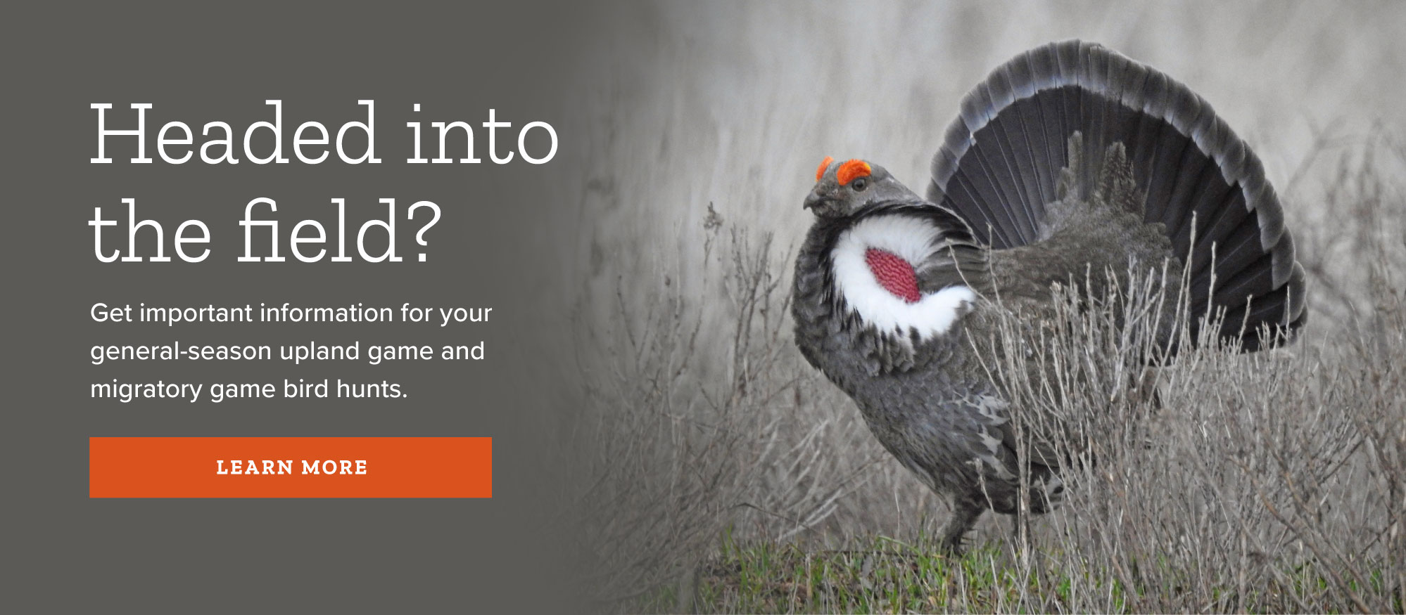
Blue Grouse (Dendragapus obscurus)
White-tailed Ptarmigan (Lagopus leucura)
Ruffed Grouse (Bonasa umbellus)
Greater Sage-grouse (Centrocercus urophasianus)
Gunnison Sage-grouse (Centrocercus minimus)
Sharp-tailed Grouse (Tympanuchus phasianellus)
Wild Turkey (Meleagris gallopavo)
Columbian Sharp-tailed Grouse (Tympanuchus phasianellus columbianus)
Quails (Odontophoridae)
Rails (Gruiformes)
Rails (Rallidae)
Virginia Rail (Rallus limicola)
Purple Gallinule (Porphyrio martinicus)
Cranes (Gruidae)
Shorebirds (Charadriiformes)
Plovers (Charadriidae)
Black-bellied Plover (Pluvialis squatarola)
American Golden-plover (Pluvialis dominica)
Snowy Plover (Charadrius nivosus)
Semipalmated Plover (Charadrius semipalmatus)
Avocets (Recurvirostridae)
Sandpipers (Scolopacidae)
Greater Yellowlegs (Tringa melanoleuca)
Lesser Yellowlegs (Tringa flavipes)
Solitary Sandpiper (Tringa solitaria)
Wandering Tattler (Tringa incana)
Spotted Sandpiper (Actitis macularius)
Upland Sandpiper (Bartramia longicauda)
Long-billed Curlew (Numenius americanus)
Hudsonian Godwit (Limosa haemastica)
Ruddy Turnstone (Arenaria interpres)
Semipalmated Sandpiper (Calidris pusilla)
Western Sandpiper (Calidris mauri)
Least Sandpiper (Calidris minutilla)
White-rumped Sandpiper (Calidris fuscicollis)
Baird's Sandpiper (Calidris bairdii)
Pectoral Sandpiper (Calidris melanotos)
Curlew Sandpiper (Calidris ferruginea)
Stilt Sandpiper (Calidris himantopus)
Short-billed Dowitcher (Limnodromus griseus)
Long-billed Dowitcher (Limnodromus scolopaceus)
Wilson's Snipe (Gallinago delicata)
American Woodcock (Scolopax minor)
Wilson's Phalarope (Phalaropus tricolor)
Jaegers (Stercorariidae)
Gulls / Terns (Laridae)
Laughing Gull (Leucophaeus atricilla)
Franklin's Gull (Leucophaeus pipixcan)
Bonaparte's Gull (Chroicocephalus philadelphia)
Ring-billed Gull (Larus delawarensis)
California Gull (Larus californicus)
Herring Gull (Larus argentatus)
Thayer's Gull (Larus glaucoides thayeri)
Lesser Black-backed Gull (Larus fuscus)
Glaucous-winged Gull (Larus glaucescens)
Glaucous Gull (Larus hyperboreus)
Black-legged Kittiwake (Rissa tridactyla)
Caspian Tern (Hydroprogne caspia)
Forster's Tern (Sterna forsteri)
Murrelets (Alcidae)
Pigeons / Doves (Columbiformes)
Pigeon / Doves (Columbidae)
Cuckoos (Cuculiformes)
Cuckoos (Cuculidae)
Owls (Strigiformes)
Barn Owl (Tytonidae)
Owls (Strigidae)
Flammulated Owl (Psiloscops flammeolus)
Western Screech-owl (Megascops kennicottii)
Great Horned Owl (Bubo virginianus)
Northern Hawk Owl (Surnia ulula)
Northern Pygmy-owl (Glaucidium gnoma)
Burrowing Owl (Athene cunicularia)
Spotted Owl (Strix occidentalis)
Great Gray Owl (Strix nebulosa)
Short-eared Owl (Asio flammeus)
Boreal Owl (Aegolius funereus)
Nightjars (Caprimulgiformes)
Nightjars (Caprimulgidae)
Hummingbirds / Swifts (Apodiformes)
Swifts (Apodidae)
Hummingbirds (Trochilidae)
Broad-billed Hummingbird (Cynanthus latirostris)
Blue-throated Hummingbird (Lampornis clemenciae)
Magnificent Hummingbird (Eugenes fulgens)
Black-chinned Hummingbird (Archilochus alexandri)
Anna's Hummingbird (Calypte anna)
Costa's Hummingbird (Calypte costae)
Calliope Hummingbird (Selasphorus calliope)
Kingfishers (Coraciiformes)
Kingfishers (Alcedinidae)
Woodpeckers (Piciformes)
Woodpeckers (Picidae)
Lewis's Woodpecker (Melanerpes lewis)
Red-headed Woodpecker (Melanerpes erythrocephalus)
Acorn Woodpecker (Melanerpes formicivorus)
Red-breasted Sapsucker (Sphyrapicus ruber)
Williamson's Sapsucker (Sphyrapicus thyroideus)
Red-naped Sapsucker (Sphyrapicus nuchalis)
Ladder-backed Woodpecker (Dryobates scalaris)
Downy Woodpecker (Dryobates pubescens)
Hairy Woodpecker (Dryobates villosus)
American Three-toed Woodpecker (Picoides dorsalis)
Northern Flicker (Colaptes auratus)
Songbirds (Passeriformes)
Flycatchers (Tyrannidae)
Olive-sided Flycatcher (Contopus cooperi)
Western Wood-pewee (Contopus sordidulus)
Willow Flycatcher (Empidonax traillii)
Southwestern Willow Flycatcher (Empidonax traillii extimus)
Least Flycatcher (Empidonax minimus)
Hammond's Flycatcher (Empidonax hammondii)
Dusky Flycatcher (Empidonax oberholseri)
Gray Flycatcher (Empidonax wrightii)
Pacific-slope Flycatcher (Empidonax difficilis)
Cordilleran Flycatcher (Empidonax occidentalis)
Black Phoebe (Sayornis nigricans)
Eastern Phoebe (Sayornis phoebe)
Vermilion Flycatcher (Pyrocephalus rubinus)
Ash-throated Flycatcher (Myiarchus cinerascens)
Great Crested Flycatcher (Myiarchus crinitus)
Brown-crested Flycatcher (Myiarchus tyrannulus)
Cassin's Kingbird (Tyrannus vociferans)
Western Kingbird (Tyrannus verticalis)
Larks (Alaudidae)
Swallows (Hirundinidae)
Tree Swallow (Tachycineta bicolor)
Violet-green Swallow (Tachycineta thalassina)
Northern Rough-winged Swallow (Stelgidopteryx serripennis)
Bank Swallow (Riparia riparia)
Jays / Crows / Magpies (Corvidae)
Gray Jay (Perisoreus canadensis)
Steller's Jay (Cyanocitta stelleri)
Blue Jay (Cyanocitta cristata)
Western Scrub-jay (Aphelocoma californica)
Pinyon Jay (Gymnorhinus cyanocephalus)
Clark's Nutcracker (Nucifraga columbiana)
Black-billed Magpie (Pica hudsonia)
Chickadees (Paridae)
(Remizidae)
(Aegithalidae)
Nuthatches (Sittidae)
Creepers (Certhiidae)
Wrens (Troglodytidae)
Cactus Wren (Campylorhynchus brunneicapillus)
Rock Wren (Salpinctes obsoletus)
Canyon Wren (Catherpes mexicanus)
Bewick's Wren (Thryomanes bewickii)
House Wren (Troglodytes aedon)
Dippers (Cinclidae)
Kinglets (Regulidae)
Gnatcatchers (Polioptilidae)
Thrushes (Turdidae)
Eastern Bluebird (Sialia sialis)
Western Bluebird (Sialia mexicana)
Mountain Bluebird (Sialia currucoides)
Townsend's Solitaire (Myadestes townsendi)
Gray-cheeked Thrush (Catharus minimus)
Swainson's Thrush (Catharus ustulatus)
Hermit Thrush (Catharus guttatus)
Wood Thrush (Hylocichla mustelina)
Thrashers / Mockingbirds / Catbirds (Mimidae)
Gray Catbird (Dumetella carolinensis)
Northern Mockingbird (Mimus polyglottos)
Sage Thrasher (Oreoscoptes montanus)
Brown Thrasher (Toxostoma rufum)
Bendire's Thrasher (Toxostoma bendirei)
Pipits (Motacillidae)
Waxwings (Bombycillidae)
Silky-flycatchers (Ptilogonatidae)
Shrikes (Laniidae)
Starlings (Sturnidae)
Vireos (Vireonidae)
White-eyed Vireo (Vireo griseus)
Yellow-throated Vireo (Vireo flavifrons)
Philadelphia Vireo (Vireo philadelphicus)
Red-eyed Vireo (Vireo olivaceus)
Warblers (Parulidae)
Blue-winged Warbler (Vermivora cyanoptera)
Tennessee Warbler (Oreothlypis peregrina)
Orange-crowned Warbler (Oreothlypis celata)
Nashville Warbler (Oreothlypis ruficapilla)
Virginia's Warbler (Oreothlypis virginiae)
Lucy's Warbler (Oreothlypis luciae)
Northern Parula (Setophaga americana)
Yellow Warbler (Setophaga petechia)
Chestnut-sided Warbler (Setophaga pensylvanica)
Magnolia Warbler (Setophaga magnolia)
Black-throated Blue Warbler (Setophaga caerulescens)
Yellow-rumped Warbler (Setophaga coronata)
Black-throated Gray Warbler (Setophaga nigrescens)
Townsend's Warbler (Setophaga townsendi)
Hermit Warbler (Setophaga occidentalis)
Black-throated Green Warbler (Setophaga virens)
Blackburnian Warbler (Setophaga fusca)
Yellow-throated Warbler (Setophaga dominica)
Grace's Warbler (Setophaga graciae)
Palm Warbler (Setophaga palmarum)
Bay-breasted Warbler (Setophaga castanea)
Blackpoll Warbler (Setophaga striata)
Black-and-white Warbler (Mniotilta varia)
American Redstart (Setophaga ruticilla)
Ovenbird (Seiurus aurocapilla)
Northern Waterthrush (Parkesia noveboracensis)
Kentucky Warbler (Geothlypis formosa)
Connecticut Warbler (Oporornis agilis)
Macgillivray's Warbler (Geothlypis tolmiei)
Common Yellowthroat (Geothlypis trichas)
Hooded Warbler (Setophaga citrina)
Wilson's Warbler (Cardellina pusilla)
Yellow-breasted Chats (Icteriidae)
Tanagers / Cardinals / Buntings (Cardinalidae)
Hepatic Tanager (Piranga flava)
Summer Tanager (Piranga rubra)
Scarlet Tanager (Piranga olivacea)
Western Tanager (Piranga ludoviciana)
Northern Cardinal (Cardinalis cardinalis)
Rose-breasted Grosbeak (Pheucticus ludovicianus)
Black-headed Grosbeak (Pheucticus melanocephalus)
Blue Grosbeak (Passerina caerulea)
Lazuli Bunting (Passerina amoena)
New World Sparrows (Passerellidae)
Green-tailed Towhee (Pipilo chlorurus)
Abert's Towhee (Melozone aberti)
Spotted Towhee (Pipilo maculatus)
Cassin's Sparrow (Peucaea cassinii)
Rufous-crowned Sparrow (Aimophila ruficeps)
American Tree Sparrow (Spizelloides arborea)
Chipping Sparrow (Spizella passerina)
Clay-colored Sparrow (Spizella pallida)
Brewer's Sparrow (Spizella breweri)
Black-chinned Sparrow (Spizella atrogularis)
Vesper Sparrow (Pooecetes gramineus)
Lark Sparrow (Chondestes grammacus)
Black-throated Sparrow (Amphispiza bilineata)
Sagebrush Sparrow (Artemisiospiza nevadensis)
Lark Bunting (Calamospiza melanocorys)
Savannah Sparrow (Passerculus sandwichensis)
Baird's Sparrow (Centronyx bairdii)
Grasshopper Sparrow (Ammodramus savannarum)
Le Conte's Sparrow (Ammospiza leconteii)
Fox Sparrow (Passerella iliaca)
Song Sparrow (Melospiza melodia)
Lincoln's Sparrow (Melospiza lincolnii)
Swamp Sparrow (Melospiza georgiana)
White-throated Sparrow (Zonotrichia albicollis)
Golden-crowned Sparrow (Zonotrichia atricapilla)
White-crowned Sparrow (Zonotrichia leucophrys)
Longspurs and Snow Buntings (Calcariidae)
Mccown's Longspur (Rhynchophanes mccownii)
Lapland Longspur (Calcarius lapponicus)
Blackbirds (Icteridae)
Bobolink (Dolichonyx oryzivorus)
Red-winged Blackbird (Agelaius phoeniceus)
Western Meadowlark (Sturnella neglecta)
Yellow-headed Blackbird (Xanthocephalus xanthocephalus)
Rusty Blackbird (Euphagus carolinus)
Brewer's Blackbird (Euphagus cyanocephalus)
Great-tailed Grackle (Quiscalus mexicanus)
Common Grackle (Quiscalus quiscula)
Bronzed Cowbird (Molothrus aeneus)
Brown-headed Cowbird (Molothrus ater)
Orchard Oriole (Icterus spurius)
Hooded Oriole (Icterus cucullatus)
Baltimore Oriole (Icterus galbula)
Finches (Fringillidae)
Brambling (Fringilla montifringilla)
Black Rosy-finch (Leucosticte atrata)
Gray-crowned Rosy-finch (Leucosticte tephrocotis)
Pine Grosbeak (Pinicola enucleator)
Purple Finch (Haemorhous purpureus)
Cassin's Finch (Haemorhous cassinii)
House Finch (Haemorhous mexicanus)
Red Crossbill (Loxia curvirostra)
White-winged Crossbill (Loxia leucoptera)
Common Redpoll (Acanthis flammea)
Lesser Goldfinch (Spinus psaltria)
Lawrence's Goldfinch (Spinus lawrencei)
Old World Sparrows (Passeridae)
Fish (Actinopterygii)
Use gills to breathe
Sculpins (Scorpaeniformes)
Sculpins (Cottidae)
(Clupeiformes)
Salmon / Trout (Salmoniformes)
Trout (Salmonidae)
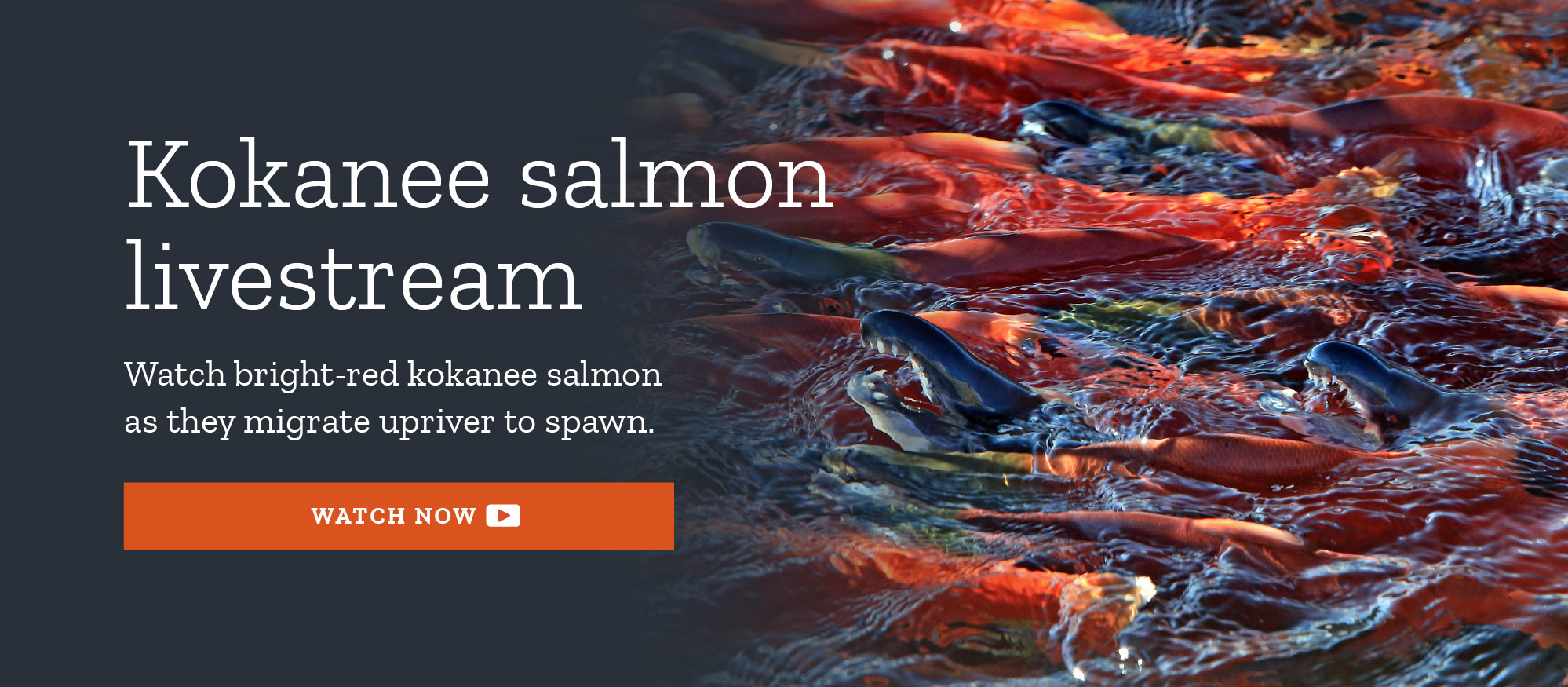
Sockeye Salmon (Kokanee) (Oncorhynchus nerka)
Cutthroat Trout (Oncorhynchus clarkii)
Lahontan Cutthroat Trout (Oncorhynchus clarkii henshawi)
Bonneville Cutthroat Trout (Oncorhynchus clarkii utah)
Colorado River Cutthroat Trout (Oncorhynchus clarkii pleuriticus)
Yellowstone Cutthroat Trout (Oncorhynchus clarkii bouvieri)
Rainbow Trout (Oncorhynchus mykiss)
Golden Trout (Oncorhynchus mykiss aguabonita)
Bear Lake Whitefish (Prosopium abyssicola)
Bonneville Cisco (Prosopium gemmifer)
Bonneville Whitefish (Prosopium spilonotus)
Mountain Whitefish (Prosopium williamsoni)
Brook Trout (Salvelinus fontinalis)
Pikes / Mudminnow (Esociformes)
Pikes / Pickerels (Esocidae)
Minnows / Suckers (Cypriniformes)
Minnows (Cyprinidae)
Brassy Minnow (Hybognathus hankinsoni)
Plains Minnow (Hybognathus placitus)
Least Chub (Iotichthys phlegethontis)
Virgin Spinedace (Lepidomeda mollispinis)
Golden Shiner (Notemigonus crysoleucas)
Emerald Shiner (Notropis atherinoides)
Spottail Shiner (Notropis hudsonius)
Sand Shiner (Notropis stramineus)
Fathead Minnow (Pimephales promelas)
Woundfin (Plagopterus argentissimus)
Colorado Pikeminnow (Ptychocheilus lucius)
Longnose Dace (Rhinichthys cataractae)
Speckled Dace (Rhinichthys osculus)
Redside Shiner (Richardsonius balteatus)
Creek Chub (Semotilus atromaculatus)
Red Shiner (Cyprinella lutrensis)
Grass Carp (Ctenopharyngodon idella)
Suckers (Catostomidae)
Catfishes (Siluriformes)
Bullheads / Catfishes (Ictaluridae)
Trout-Perch (Percopsiformes)
Trout-perch (Percopsidae)
Killfish / Mollies (Cyprinodontiformes)
Killfishes (Fundulidae)
Livebearers (Mosquitofish / Mollies / Swordtails) (Poeciliidae)
(Gasterosteiformes)
Sticklebacks (Gasterosteidae)
Perch / Sticklebacks (Perciformes)
Temperate Basses (Moronidae)
Sunfishes (Centrarchidae)
Sacramento Perch (Archoplites interruptus)
Green Sunfish (Lepomis cyanellus)
Bluegill (Lepomis macrochirus)
Smallmouth Bass (Micropterus dolomieu)
Largemouth Bass (Micropterus salmoides)
White Crappie (Pomoxis annularis)
Perches (Percidae)
Cichlids (Cichlidae)
Burbots (Gadiformes)
Burbot (Gadidae)
Mammals (Mammalia)
Have hair, feed young milk, warm blooded.
Opossums (Didelphimorphia)
Opossums (Didelphidae)
Shrews (Soricomorpha)
Shrews (Soricidae)
Bats (Chiroptera)
(Phyllostomidae)
Bats (Vespertilionidae)
Little Brown Myotis (Myotis lucifugus)
Yuma Myotis (Myotis yumanensis)
Long-eared Myotis (Myotis evotis)
Fringed Myotis (Myotis thysanodes)
Long-legged Myotis (Myotis volans)
California Myotis (Myotis californicus)
Western Small-footed Myotis (Myotis ciliolabrum)
Silver-haired Bat (Lasionycteris noctivagans)
Canyon Bat (Parastrellus hesperus)
Big Brown Bat (Eptesicus fuscus)
Western Red Bat (Lasiurus blossevillii)
Spotted Bat (Euderma maculatum)
Townsend's Big-eared Bat (Corynorhinus townsendii)
(Molossidae)
Rabbits / Hares (Lagomorpha)
Pikas (Ochotonidae)
Rabbits (Leporidae)
Rodents (Rodentia)
Squirrels (Sciuridae)
Least Chipmunk (Neotamias minimus)
Yellow-pine Chipmunk (Neotamias amoenus)
Cliff Chipmunk (Neotamias dorsalis)
Uinta Chipmunk (Neotamias umbrinus)
Hopi Chipmunk (Neotamias rufus)
Yellow-bellied Marmot (Marmota flaviventris)
White-tailed Antelope Squirrel (Ammospermophilus leucurus)
Uinta Ground Squirrel (Urocitellus armatus)
Belding's Ground Squirrel (Urocitellus beldingi)
Thirteen-lined Ground Squirrel (Ictidomys tridecemlineatus)
Spotted Ground Squirrel (Xerospermophilus spilosoma)
Rock Squirrel (Otospermophilus variegatus)
Golden-mantled Ground Squirrel (Callospermophilus lateralis)
Wyoming Ground Squirrel (Urocitellus elegans)
Piute Ground Squirrel (Urocitellus mollis)
White-tailed Prairie Dog (Cynomys leucurus)
Utah Prairie Dog (Cynomys parvidens)
Gunnison's Prairie Dog (Cynomys gunnisoni)
Abert's Squirrel (Sciurus aberti)
Pocket Gophers (Geomyidae)
Botta's Pocket Gopher (Thomomys bottae)
Skull Valley Pocket Gopher (Thomomys bottae robustus)
Pocket Mice / Kangaroo Rats (Heteromyidae)
Olive-backed Pocket Mouse (Perognathus fasciatus)
Plains Pocket Mouse (Perognathus flavescens)
Silky Pocket Mouse (Perognathus flavus)
Little Pocket Mouse (Perognathus longimembris)
Great Basin Pocket Mouse (Perognathus parvus)
Dark Kangaroo Mouse (Microdipodops megacephalus)
Ord's Kangaroo Rat (Dipodomys ordii)
Chisel-toothed Kangaroo Rat (Dipodomys microps)
[a Race of the] Chisel-toothed Kangaroo Rat (Dipodomys microps celsus)
Desert Kangaroo Rat (Dipodomys deserti)
Merriam's Kangaroo Rat (Dipodomys merriami)
Long-tailed Pocket Mouse (Chaetodipus formosus)
Rock Pocket Mouse (Chaetodipus intermedius)
Beavers (Castoridae)
New World Mice / Rats / Voles (Cricetidae)
Western Harvest Mouse (Reithrodontomys megalotis)
Cactus Mouse (Peromyscus eremicus)
Deer Mouse (Peromyscus maniculatus)
Canyon Mouse (Peromyscus crinitus)
Brush Mouse (Peromyscus boylii)
Pinon Mouse (Peromyscus truei)
Northern Rock Deermouse (Peromyscus nasutus)
Northern Grasshopper Mouse (Onychomys leucogaster)
Southern Grasshopper Mouse (Onychomys torridus)
White-throated Woodrat (Neotoma albigula)
Desert Woodrat (Neotoma lepida)
Stephens' Woodrat (Neotoma stephensi)
Mexican Woodrat (Neotoma mexicana)
Bushy-tailed Woodrat (Neotoma cinerea)
Southern Red-backed Vole (Myodes gapperi)
Western Heather Vole (Phenacomys intermedius)
Meadow Vole (Microtus pennsylvanicus)
Montane Vole (Microtus montanus)
Virgin River Montane Vole (Microtus montanus rivularis)
Long-tailed Vole (Microtus longicaudus)
Water Vole (Microtus richardsoni)
Mogollon Vole (Microtus mogollonensis)
Old World Mice / Rats (Muridae)
Jumping Mice (Dipodidae)
Porcupines (Erethizontidae)
Nutrias (Myocastoridae)
Carnivores (Carnivora)
Wolves / Coyotes / Foxes (Canidae)
Bears (Ursidae)
Raccoons (Procyonidae)
Weasels (Mustelidae)
Pacific Marten (Martes caurina)
Long-tailed Weasel (Mustela frenata)
Black-footed Ferret (Mustela nigripes)
Skunks (Mephitidae)
Cats (Felidae)
Deer / Sheep / Goats / Bison / Pronghorn (Artiodactyla)
Deer / Moose / Elk (Cervidae)
Elk (or Wapiti) (Cervus elaphus)
Mule Deer (Odocoileus hemionus)
Pronghorns (Antilocapridae)
Bison / Goat / Sheep (Bovidae)
Horses (Perissodactyla)
Horses (Equidae)
Turtles (Chelonia)
Turtles (Cryptodeira)
Snapping Turtles (Chelydridae)
Pond Turtles (Emydidae)
Tortoises (Testudinidae)
Softshell Turtles (Trionychidae)
Reptiles (Reptilia)
Cold blooded, lay eggs on land
Lizards / Snakes (Squamata)
Alligator Lizards (Anguidae)
(Gekkonidae)
(Helodermatidae)
Sagebush / Spiny Lizards (Phrynosomatidae)
Zebra-tailed Lizard (Callisaurus draconoides)
Common Lesser Earless Lizard (Holbrookia maculata)
Desert Horned Lizard (Phrynosoma platyrhinos)
Greater Short-horned Lizard (Phrynosoma hernandesi)
Common Sagebrush Lizard (Sceloporus graciosus)
Desert Spiny Lizard (Sceloporus magister)
Western Fence Lizard (Sceloporus occidentalis)
Eastern Fence Lizard (Sceloporus undulatus)
Long-tailed Brush Lizard (Urosaurus graciosus)
(Crotaphytidae)
(Iguanidae)
Skinks (Scincidae)
(Teiidae)
(Xantusiidae)
Boas (Boidae)
Colubrid Snakes (Colubridae)
Glossy Snake (Arizona elegans)
Eastern Racer (Coluber constrictor)
Ring-necked Snake (Diadophis punctatus)
Great Plains Ratsnake (Pantherophis emoryi)
Desert Nightsnake (Hypsiglena chlorophaea)
California Kingsnake (Lampropeltis californiae)
Sonoran Mountain Kingsnake (Lampropeltis pyromelana)
Utah Milksnake (Lampropeltis triangulum)
Striped Whipsnake (Coluber taeniatus)
Spotted Leaf-nosed Snake (Phyllorhynchus decurtatus)
Gophersnake (Pituophis catenifer)
Long-nosed Snake (Rhinocheilus lecontei)
Western Patch-nosed Snake (Salvadora hexalepis)
Groundsnake (Sonora semiannulata)
Smith's Black-headed Snake (Tantilla hobartsmithi)
Black-necked Gartersnake (Thamnophis cyrtopsis)
Terrestrial Gartersnake (Thamnophis elegans)
Common Gartersnake (Thamnophis sirtalis)
Western Lyresnake (Trimorphodon lambda)
Smooth Greensnake (Opheodrys vernalis)
Pyro Mountain Kingsnake (Lampropeltis pyromelana infralabialis)
(Leptotyphlopidae)
Vipers (Viperidae)
Segmented Worms (Annelida)
Long cylindrical body. Have a fluid-filled cavity (coelom) between the outer body wall and the gut that is typically segmented into a series of compartments.
Earthworms, tube worms, leeches (Clitellata)
Proboscis Leeches (Rhynchobdellida)
Proboscis Leeches (Glossiphoniidae)
(Acanthobdellida)
Jawed Leeches (Erpobdellidae)
(Haemopidae)
Fairy Shrimp, Crayfish, Amphipods, Pill Bugs (Crustacea)
Hard exoskeleton, two compound eyes, two paris of antennae, three paris of mouth parts. Aquatic, gill breathing.
Fairy Shrimp (Branchiopoda)
Brine Shrimp (Anostraca)
Chirocephalid Brine shrimp (Chirocephalidae)
(Artemiidae)
Branchinectid Brine shrimp (Branchinectidae)
Streptocephalid Brine shrimp (Streptocephalidae)
(Thamnocephalidae)
Fairy Shrimp (Notostraca)
Fairy shrimp (Triopsidae)
(Diplostraca)
Prong-gilled Mayflies (Leptestheriidae)
Crayfish / Amphipods / Pill Bugs (Malacostraca)
Crayfish (Decapoda)
Cambarid crayfishes (Cambaridae)
Astacid Crayfishes (Astacidae)
Amphipods (Amphipoda)
Gammarid Amphipods (Crangonyctidae)
Insects, Springtails, Millipedes (Mandibulata)
Identified by mandible mouth parts and 3 distinct body parts (head, thorax, abdomen).
Insects (Insecta)
Animals having 3 pair of legs, 3 body sections, generally 1 or 2 pair of wings, 1 pair of antennae.
Beetles (Coleoptera)
Tiger Beetles (Cicindelidae)
A Tiger Beetle (Cicindela formosa)
A Tiger Beetle (Cicindela formosa gibsoni)
Beach-dune Tiger Beetle (Cicindela hirticollis)
A Tiger Beetle (Cicindela hirticollis corpuscula)
A Tiger Beetle (Cicindela limbata)
Coral Pink Sand Dunes Tiger Beetle (Cicindela albissima)
A Tiger Beetle (Cicindela nevadica)
A Tiger Beetle (Cicindela nevadica tubensis)
A Tiger Beetle (Cicindela nigrocoerulea)
A Tiger Beetle (Cicindela obsoleta)
A Tiger Beetle (Cicindela tranquebarica)
A Tiger Beetle (Cicindela tranquebarica kirbyi)
A Tiger Beetle (Cicindela tranquebarica moapana)
Little White Tiger Beetle (Cicindela lepida)
A Tiger Beetle (Cicindela purpurea)
A Tiger Beetle (Cicindela purpurea audubonii)
A Tiger Beetle (Cicindela longilabris)
A Tiger Beetle (Cicindela nebraskana)
A Tiger Beetle (Cicindela repanda)
A Tiger Beetle (Cicindela oregona)
Maricopa Tiger Beetle (Cicindela oregona maricopa)
A Tiger Beetle (Cicindela oregona navajoensis)
A Tiger Beetle (Cicindela decemnotata)
A Tiger Beetle (Cicindela fulgida)
A Tiger Beetle (Cicindela parowana)
A Tiger Beetle (Cicindela tenuicincta)
A Tiger Beetle (Cicindela willistoni)
A Tiger Beetle (Cicindela willistoni echo)
A Tiger Beetle (Cicindela punctulata)
Great Plains Toad (Anaxyrus cognatus)
Arizona Toad (Anaxyrus microscaphus)
Canyon Treefrog (Dryophytes arenicolor)
Western Chorus Frog (Pseudacris maculata)
Pacific Treefrog (Hyliola sierrae)
Baja California Treefrog (Hyliola hypochondriaca)
Great Basin Spadefoot (Spea intermontana)
Mexican Spadefoot (Spea multiplicata)
Green Frog (Lithobates clamitans)
Northern Leopard Frog (Lithobates pipiens)
Yavapai Leopard Frog (Lithobates yavapaiensis)
Tiger Salamander (Ambystoma tigrinum)
(Cicindela tranquebarica parallelonota)
Western Toad (Anaxyrus boreas)
Woodhouse's Toad (Anaxyrus woodhousii)
(Cicindela tranquebarica lassenica)
American Bullfrog (Lithobates catesbeianus)
(Cicindela longilabris perviridis)
Plains Spadefoot (Spea bombifrons)
(Cicindela purpurea cimarrona)
(Cicindela parowana remittens)
Red-spotted Toad (Anaxyrus punctatus)
(Cicindela tranquebarica tranquebarica)
(Cicindela longilabris laurentii)
Relict Leopard Frog (Lithobates onca)
Diving Water Beetles (Dytiscidae)
(Hydraenidae)
Crawling Water Beetles (Hydrophilidae)
(Scarabaeidae)
True Flies (Diptera)
Net-winged Midges (Blephariceridae)
Mayflies (Ephemeroptera)
Oligoneurid Mayflies (Oligoneuriidae)
Caenid Mayflies (Caenidae)
American White Pelican (Pelecanus erythrorhynchos)
Clark's Grebe (Aechmophorus clarkii)
Ephemerellid Mayflies (Ephemerellidae)
Brown Pelican (Pelecanus occidentalis)
Least Bittern (Ixobrychus exilis)
Bufflehead (Bucephala albeola)
Hooded Merganser (Lophodytes cucullatus)
Common Merganser (Mergus merganser)
Prairie Falcon (Falco mexicanus)
Double-crested Cormorant (Phalacrocorax auritus)
Ephemeridae (Ephemeridae)
Ameletid Mayflies (Ameletidae)
Little Blue Heron (Egretta caerulea)
Tricolored Heron (Egretta tricolor)
Green Heron (Butorides virescens)
Isonychia (Isonychiidae)
Heptageniid Mayflies (Heptageniidae)
Fulvous Whistling-duck (Dendrocygna bicolor)
Northern Shoveler (Spatula clypeata)
Eurasian Wigeon (Mareca penelope)
American Wigeon (Mareca americana)
Canvasback (Aythya valisineria)
Ring-necked Duck (Aythya collaris)
Long-tailed Duck (Clangula hyemalis)
Surf Scoter (Melanitta perspicillata)
White-winged Scoter (Melanitta fusca)
Red-breasted Merganser (Mergus serrator)
Ruddy Duck (Oxyura jamaicensis)
Turkey Vulture (Cathartes aura)
California Condor (Gymnogyps californianus)
Bald Eagle (Haliaeetus leucocephalus)
Peregrine Falcon (Falco peregrinus)
Siphlonurid Mayflies (Siphlonuridae)
Baetid Mayflies (Baetidae)
Greater White-fronted Goose (Anser albifrons)
Snow Goose (Anser caerulescens)
Blue-winged Teal (Spatula discors)
Black Scoter (Melanitta americana)
Common Goldeneye (Bucephala clangula)
Northern Goshawk (Accipiter gentilis)
Common Black-hawk (Buteogallus anthracinus)
Broad-winged Hawk (Buteo platypterus)
Swainson's Hawk (Buteo swainsoni)
Zone-tailed Hawk (Buteo albonotatus)
Red-tailed Hawk (Buteo jamaicensis)
Ferruginous Hawk (Buteo regalis)
Leptophlebiid Mayflies (Leptophlebiidae)
Cackling Goose (Branta hutchinsii)
Green-winged Teal (Anas crecca)
American Black Duck (Anas rubripes)
Sharp-shinned Hawk (Accipiter striatus)
Leptohyphidae (Leptohyphidae)
Ametropodid Mayflies (Ametropodidae)
Polymitarcyidae (Polymitarcyidae)
Acanthametropodid Mayflies (Acanthametropodidae)
Pseudironidae (Pseudironidae)
(Heteroptera)
(Hydrometridae)
Butterflies / Moths (Lepidoptera)
Skipper Butterflies (Hesperiidae)
Sandhill Crane (Antigone canadensis)
Whooping Crane (Grus americana)
Black-bellied Plover (Pluvialis squatarola)
American Golden-plover (Pluvialis dominica)
Snowy Plover (Charadrius nivosus)
Semipalmated Plover (Charadrius semipalmatus)
Killdeer (Charadrius vociferus)
Mountain Plover (Charadrius montanus)
Black-necked Stilt (Himantopus mexicanus)
American Avocet (Recurvirostra americana)
Greater Yellowlegs (Tringa melanoleuca)
Lesser Yellowlegs (Tringa flavipes)
Solitary Sandpiper (Tringa solitaria)
Wandering Tattler (Tringa incana)
Spotted Sandpiper (Actitis macularius)
Upland Sandpiper (Bartramia longicauda)
Long-billed Curlew (Numenius americanus)
Hudsonian Godwit (Limosa haemastica)
Ruddy Turnstone (Arenaria interpres)
Semipalmated Sandpiper (Calidris pusilla)
Western Sandpiper (Calidris mauri)
Least Sandpiper (Calidris minutilla)
White-rumped Sandpiper (Calidris fuscicollis)
Baird's Sandpiper (Calidris bairdii)
Pectoral Sandpiper (Calidris melanotos)
Curlew Sandpiper (Calidris ferruginea)
Stilt Sandpiper (Calidris himantopus)
Short-billed Dowitcher (Limnodromus griseus)
Long-billed Dowitcher (Limnodromus scolopaceus)
Wilson's Snipe (Gallinago delicata)
American Woodcock (Scolopax minor)
Wilson's Phalarope (Phalaropus tricolor)
Red-necked Phalarope (Phalaropus lobatus)
Red Phalarope (Phalaropus fulicarius)
Pomarine Jaeger (Stercorarius pomarinus)
Parasitic Jaeger (Stercorarius parasiticus)
Long-tailed Jaeger (Stercorarius longicaudus)
Laughing Gull (Leucophaeus atricilla)
Franklin's Gull (Leucophaeus pipixcan)
Bonaparte's Gull (Chroicocephalus philadelphia)
Ring-billed Gull (Larus delawarensis)
California Gull (Larus californicus)
Herring Gull (Larus argentatus)
Thayer's Gull (Larus glaucoides thayeri)
Lesser Black-backed Gull (Larus fuscus)
Swallowtail Butterflies (Papilionidae)
Sawflies / Wasps / Bees / Ants (Hymenoptera)
(Megachilidae)
Bees (Apidae)
Gambel's Quail (Callipepla gambelii)
Wild Turkey (Meleagris gallopavo)
Virginia Rail (Rallus limicola)
White-tailed Ptarmigan (Lagopus leucura)
Ruffed Grouse (Bonasa umbellus)
Columbian Sharp-tailed Grouse (Tympanuchus phasianellus columbianus)
Gunnison Sage-grouse (Centrocercus minimus)
Greater Sage-grouse (Centrocercus urophasianus)
Sharp-tailed Grouse (Tympanuchus phasianellus)