
Regulations for recreational access along the Upper Weber River
In November 2017, the Utah Supreme Court issued a decision in Utah Stream Access Coalition v. Orange Street Development. That decision modified the rules related to public recreational access along a segment of the Weber River in Summit County.
What did the Utah Supreme Court decide?
The Court found that a segment of the Weber River in Summit County was navigable under the Public Waters Access Act in Utah Code. The Act provides that "the public may use a public water for recreational activity if. . . the public water. . . is a navigable water."
The evidence supporting navigability involved historic railroad tie and log floats on the upper Weber River between Holiday Park and Echo Reservoir. After evaluating this evidence, the Court concluded the log drives were sufficient proof of navigability and recognized public recreational access.
What does this mean for the public?
Based on the Court's ruling, the following parameters will apply to public access on the upper Weber River between Holiday Park and Echo Reservoir:
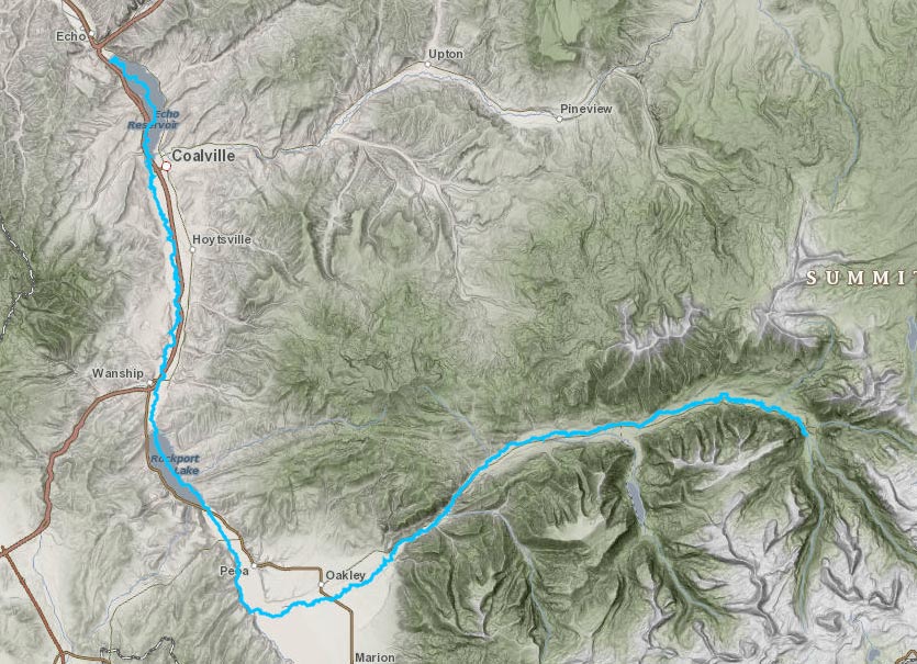
- Access corridor length — Based on historical records, water flows and topography, log drives began at the confluence of the Main Fork and Middle Fork of the Weber River in Holiday Park and continued approximately 40 miles downstream to Echo. As such, public recreational access in the Weber River begins at the confluence of the Middle and Main Forks and extends downstream to Echo Reservoir*.
- Access corridor width — Recreational access is limited to the bed of the Weber River within the ordinary highwater mark. The permanent vegetative line along the river will serve as both the ordinary highwater mark and the access boundary.
- Activities allowed — Use is limited to water-based recreational activities.
- Trespass — Access rights on the river do not allow recreational users to trespass on properly posted, private property above the river's permanent vegetative line. Access to and from the river is limited to the following:
- Public access points (i.e., public land, highway right-of-ways, private property that is not posted, etc.)
- Properly posted, private property with landowner permission
- Portage — A person may leave the riverbed to travel (or portage) around a dangerous obstruction in the river, as long as that person takes the most direct route that is closest to the water.
Map of the Weber River
Map shows affected area of the Weber River from Echo Reservoir, upstream to its headwaters near Holiday Park.