|
Methods
Study Area
Because of the size of the GSL ecosystem, the original organizing group of the GSL Waterbird Survey decided to concentrate the survey efforts for the five-year study on the known areas of waterbird concentration within the GSL ecosystem. In general, this area included the GSL surface, shoreline, and associated wetlands, including the three major delta regions and nearby wetland complexes that drain into the GSL. Within this focus area, we identified sites to be surveyed in all the primary habitats, which included open water, shoreline, managed and unmanaged wetlands, and points of fresh/salt water interface (Figure 1). Most of the survey areas occurred near the east side, and north and south ends of the lake. There were a few survey areas that were placed on the west side and at the extreme north and south ends of the lake to cover more xeric environments. Of the four regions of the lake proper, only the North Arm was left unsurveyed.
Figure 1. Great Salt Lake Waterbird Survey areas classified by habitat type.
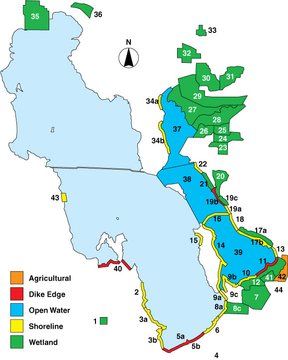
Actual survey sites included all the primary wetlands, and all of the shoreline on the east side of the lake from Stansbury Island on the south to and including the east side of Promontory Point on the north end (Figure 1, Table 2). Open water was surveyed at Farmington Bay, Bear River Bay, and Ogden Bay west to a geo-referenced line between Antelope and Fremont islands. An estimated 73% of important wetlands, largely within duck clubs, was not covered by this effort because of limited access and man power.
Organizers of actual survey sites took into consideration land ownership, potential access, proximity to other survey areas, habitat type(s), the ability to recruit surveyors, specialized equipment needs and other logistical factors. The selection of actual survey routes and area sizes was largely predicated on the capacity to survey the area in four-hours or less. Survey areas were mapped and assigned a survey area name and number. Eventually, each survey was developed into a survey polygon and geo-referenced for purposes of assessing relative avian population. Over the five-year study period, five new survey areas were included into the project.
Table 2. Summary of GSL Waterbird Survey areas.
|
Area Number
|
Area Name
|
Years
Surveyed
|
Survey Technique
|
Mode of Travel
|
Site Description
|
| 1 |
Timpie Springs WMA
|
1997-2001
|
TC
|
Driving
|
State managed wetland
|
| 2 |
Stansbury Island North
|
1999-2001
|
AR
|
Airplane
|
Private Shoreline
|
| 3a |
Stansbury Island South - N
|
1997-2001
|
TC w/PS
|
ATV/Walking
|
Shoreline
|
| 3b |
Stansbury Island South - S
|
1997-2001
|
TC w/PS
|
ATV/Walking
|
Shoreline
|
| 4 |
Interstate 80 South
|
Not Surveyed
|
|
|
|
| 5a |
Interstate 80 North - N
|
1997-2001
|
TC w/PS (semi-circular plots)
|
Driving
|
Shoreline
|
| 5b |
Interstate 80 North - S
|
1997-2001
|
TC
|
Driving
|
Wetland-flooded area
|
| 6 |
Saltair
|
1997-2001
|
TC w/PS
|
Walking
|
Shoreline
|
| 7 |
Associated Duck Club
|
1997-2001
|
TC
|
Driving/Walking
|
Private duck club
|
| 8a |
Kennecott - Lakeside
|
1997-2001
|
TC w/PS
|
Walking
|
Shoreline
|
| 8c |
Kennecott - ISSR
|
1997-2001
|
TC
|
Walking
|
Privately managed wetland
|
| 9a |
Audubon Lakeside
|
1997-2001
|
TC w/PS
|
ATV/Walking
|
Shoreline
|
| 9b |
Audubon North
|
1997-2001
|
TC w/PS
|
ATV/Walking
|
Shoreline
|
| 9c |
Audubon Interior
|
2001
|
TC w/AC
|
ATV/Walking
|
Privately managed wetland
|
| 10 |
Crystal Lakeside
|
1997-2001
|
TC
|
Airboat
|
Marsh
|
| 11 |
Farmington Bay Lakeside
|
1997-2001
|
TC w/PS
|
Driving
|
Shoreline
|
| 12 |
Farmington Bay WMA
|
1997-2001
|
TC w/AC
|
Driving
|
State managed wetland
|
| 13 |
West Farmington
|
1997-2001
|
TC w/PS
|
Walking
|
Shoreline
|
| 14 |
Antelope Island East
|
1997-2001
|
TC
|
Driving
|
Island shoreline
|
| 15 |
Antelope Island West
|
1997-2001
|
TC w/PS
|
Walking
|
Island shoreline
|
| 16 |
Antelope Island Causeway
|
1997-2001
|
TC
|
Driving
|
Road to island
|
| 17a |
West Kaysville - Interior
|
1997-2001
|
TC
|
Airboat
|
Marsh
|
| 17b |
West Kaysville - Shore
|
1997-2001
|
TC w/PS ('97), TC ('98-'01)
|
ATV/Walking/airboat
|
Shoreline
|
| 18 |
West Layton
|
1997-2001
|
TC w/PS
|
Walking
|
Shoreline
|
| 19a |
Howard Slough WMA - Shore
|
1997-2001
|
TC w/PS
|
Walking
|
Shoreline
|
| 19b |
Howard Slough WMA - Dike
|
1997-2001
|
TC
|
Driving
|
Diked shoreline
|
| 19c |
Howard Slough WMA - Pond
|
1997-2001
|
TC w/AC ('97), TC ('98-'01)
|
Driving/Walking
|
State managed wetland
|
| 20 |
Ogden Bay WMA
|
1997-2001
|
TC w/AC
|
Driving
|
State managed wetland
|
| 21 |
Ogden Bay Lakeside
|
1997-2001
|
TC
|
Airboat
|
Marsh
|
| 22 |
Ogden Bay North
|
1998-2001
|
TC
|
Airboat
|
Shoreline
|
| 23 |
Rainbow
|
1998-2001
|
TC
|
Driving
|
Private duck club
|
| 24 |
South Harold
|
1998-2001
|
TC
|
Driving
|
State managed wetland
|
| 25 |
Harold Crane WMA
|
1997-2001
|
TC w/AC
|
Driving
|
State managed wetland
|
| 26 |
West Harold Crane Mud Bar
|
Not Surveyed
|
|
|
|
| 27 |
South Bear River
|
1997-2001
|
TC
|
Airboat
|
Federal managed wetland
|
| 28 |
Willard Spur
|
1997-2001
|
TC ('97), AR ('97-'01)
|
Airboat/Airplane
|
Federal managed wetland
|
| 29 |
Bear River Refuge
|
1997-2001
|
TC
|
Driving
|
Federal managed wetland
|
| 30 |
Bear River Club
|
1997-2001
|
TC
|
Driving/Walking
|
Private duck club
|
| 31 |
Chesapeake
|
Not Surveyed
|
|
|
|
| 32 |
Public Shooting Grounds WMA
|
1997-2001
|
TC w/AC
|
Driving
|
State managed wetland
|
| 33 |
Salt Creek WMA
|
1997-2001
|
TC w/AC
|
Driving
|
State managed wetland
|
| 34a |
East Promontory - N
|
1997-2001
|
TC w/PS
|
Walking
|
Shoreline
|
| 34b |
East Promontory - S
|
1997-2001
|
TC
|
Driving
|
Shoreline
|
| 35 |
Locomotive Springs WMA
|
1997, 2001
|
TC w/AC
|
Driving
|
State managed wetland
|
| 36 |
Salt Wells Flat WHA
|
1997-2001
|
TC w/PS & AC
|
ATV/Walking
|
Federal shoreline, wetland, mudflat
|
| 37 |
Bear River Bay
|
1997-2001
|
AR
|
Airplane
|
Open water
|
| 38 |
Ogden Bay
|
1997-2001
|
AR
|
Airplane
|
Open water
|
| 39 |
Farmington Bay
|
1997-2001
|
AR
|
Airplane
|
Open water
|
| 40 |
Magcorp
|
1998-2001
|
TC
|
Driving
|
Two lakeside ponds
|
| 41 |
New State Duck Club
|
1999, 2001
|
TC
|
Motorized Boat
|
Private duck club
|
| 42 |
East Farmington Bay
|
1999-2001
|
TC
|
Driving
|
Agricultural, urban, industrial lands
|
| 43 |
Deardens Knoll
|
1999-2001
|
TC w/PS
|
Driving
|
US Airforce/BLM public land
|
| 44 |
Jordan River
|
1999-2000
|
AR
|
Airplane
|
Private agricultural land
|
|