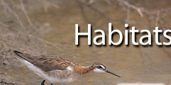
Bird Habitats within the Great Salt Lake Ecosystem
Understanding habitats, habitat relationships, and habitat use by avian species is vital when considering ecological relationships and conservation planning. Habitats provide food, shelter, cover, nesting substrates, brood rearing, travel lanes, protection, resting, and other external needs for bird survival.
 The close proximity of Great Salt Lake (GSL) to the Wasatch Range and the riverine environments of the Bear, Weber, Ogden, and Jordan rivers, and other smaller drainages play a principal role in GSL ecosystem ecology. The terminal nature of the lake, with its various saline systems and associated halophiles (salt tolerant organisms) contributes greatly to its ecological uniqueness. This is a shallow lake; some parts of the lake shoreline migrate more than 880 yards (805 m) from spring to fall depending on the water and evaporation year. Shallow water and shoreline fluctuations are fundamental ingredients in the creation of highly productive habitats for wading birds. Other species use deep water and other lake associated habitats. Within the GSL basin there are essentially four water regions with differing ecologies: Bear River Bay, Farmington Bay, Gilbert Bay (south arm) and Gunnison Bay (north arm). Each of these regions except Gunnison Bay has an extensive wetland system that forms at a river mouth. The ecology of each lake region is driven by varying degrees of salinity, among other important features. The presence or absence of fresh water dramatically affects how different guilds of aquatic birds use the system. The distance to land from open water influences bird use. Within the complexities of emergent wetlands there are microhabitats that shape bird use and activity patterns. So, habitat use can be extensive or minute, some habitats are even invisible to the eye but not the wing. For example, American white pelicans use invisible travel lanes in the sky between Gunnison Island, where they nest, and fresh water, where they fish. These “roads in the sky” are influenced by thermals occurring above island and mountain ridges and wind patterns aloft. While at the GSL birds will use a variety of habitats to meet their needs. A bird will not be present or will not linger if the suite of habitats needed is not available. The close proximity of Great Salt Lake (GSL) to the Wasatch Range and the riverine environments of the Bear, Weber, Ogden, and Jordan rivers, and other smaller drainages play a principal role in GSL ecosystem ecology. The terminal nature of the lake, with its various saline systems and associated halophiles (salt tolerant organisms) contributes greatly to its ecological uniqueness. This is a shallow lake; some parts of the lake shoreline migrate more than 880 yards (805 m) from spring to fall depending on the water and evaporation year. Shallow water and shoreline fluctuations are fundamental ingredients in the creation of highly productive habitats for wading birds. Other species use deep water and other lake associated habitats. Within the GSL basin there are essentially four water regions with differing ecologies: Bear River Bay, Farmington Bay, Gilbert Bay (south arm) and Gunnison Bay (north arm). Each of these regions except Gunnison Bay has an extensive wetland system that forms at a river mouth. The ecology of each lake region is driven by varying degrees of salinity, among other important features. The presence or absence of fresh water dramatically affects how different guilds of aquatic birds use the system. The distance to land from open water influences bird use. Within the complexities of emergent wetlands there are microhabitats that shape bird use and activity patterns. So, habitat use can be extensive or minute, some habitats are even invisible to the eye but not the wing. For example, American white pelicans use invisible travel lanes in the sky between Gunnison Island, where they nest, and fresh water, where they fish. These “roads in the sky” are influenced by thermals occurring above island and mountain ridges and wind patterns aloft. While at the GSL birds will use a variety of habitats to meet their needs. A bird will not be present or will not linger if the suite of habitats needed is not available.
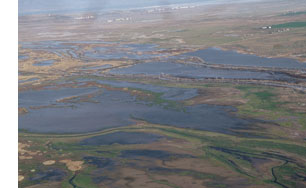 Within the GSL geographic framework there is an expansive network of habitats with the major ones in this network listed below. This habitat network provides birds all the life sustaining requirements needed during their presence at the lake as breeders or migrants. The value of habitat interrelationships cannot be over stated. GSL habitat uniqueness is driven by the close relationship between saline and fresh water. At the saltwater/freshwater interface plant communities are kept in constant flux with seasonal variation and periods of climatic change. This dynamic keeps habitats fresh and vigorous. It is similar to the effect an estuary has on life forms in an ocean environment. Within the GSL geographic framework there is an expansive network of habitats with the major ones in this network listed below. This habitat network provides birds all the life sustaining requirements needed during their presence at the lake as breeders or migrants. The value of habitat interrelationships cannot be over stated. GSL habitat uniqueness is driven by the close relationship between saline and fresh water. At the saltwater/freshwater interface plant communities are kept in constant flux with seasonal variation and periods of climatic change. This dynamic keeps habitats fresh and vigorous. It is similar to the effect an estuary has on life forms in an ocean environment.
The following is a brief review of the primary GSL bird habitats.
Salt Water
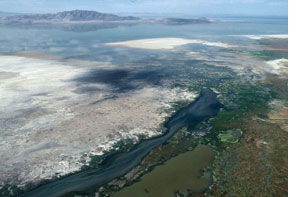
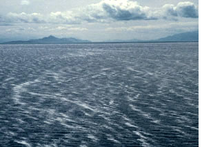 The main body of the GSL is salty; often, the brines exceed ocean salinities, which are approximately three percent salt by volume. There are four substantial bays that represent the main salt systems of the lake, listed here from the most saline to the least: Gunnison Bay, Gilbert Bay, Farmington Bay and Bear River Bay (refer to the link ”Report Contents” above for a more detailed account of these geographies). When the salinities exceed 10% and are less than 20%, as often occurs in Gilbert Bay, significant populations of two salt tolerant invertebrates thrive. Brine shrimp and brine flies are seasonally abundant during the spring, summer and fall, and are a highly nutritious bird food. Shallow reaches of salt water are also used by large flocks of resting shorebirds and rafts of migratory waterfowl. These salt water systems also include nesting habitats for some aquatic colonial birds in the form of bars, islands and flats. Birds that use these salty systems and the food they provide must be able to cope with salt in their diet either through a physiological or mechanical strategy. The primary open salt water users are eared grebes, Wilson’s and red-necked phalaropes, California and ring-billed gulls, fall Franklin’s gulls, northern shovelers and green-winged teal, and wintering common goldeneyes. The main body of the GSL is salty; often, the brines exceed ocean salinities, which are approximately three percent salt by volume. There are four substantial bays that represent the main salt systems of the lake, listed here from the most saline to the least: Gunnison Bay, Gilbert Bay, Farmington Bay and Bear River Bay (refer to the link ”Report Contents” above for a more detailed account of these geographies). When the salinities exceed 10% and are less than 20%, as often occurs in Gilbert Bay, significant populations of two salt tolerant invertebrates thrive. Brine shrimp and brine flies are seasonally abundant during the spring, summer and fall, and are a highly nutritious bird food. Shallow reaches of salt water are also used by large flocks of resting shorebirds and rafts of migratory waterfowl. These salt water systems also include nesting habitats for some aquatic colonial birds in the form of bars, islands and flats. Birds that use these salty systems and the food they provide must be able to cope with salt in their diet either through a physiological or mechanical strategy. The primary open salt water users are eared grebes, Wilson’s and red-necked phalaropes, California and ring-billed gulls, fall Franklin’s gulls, northern shovelers and green-winged teal, and wintering common goldeneyes.
|
Fresh Water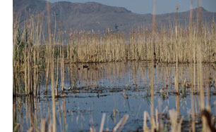
Fresh water occurs within the ecosystem mostly in the form of rivers and impoundments. Most of these impoundments are located inside managed wetlands and water storage or retention reservoirs. Fresh water also disperses into several types of wetlands, where it is the building block of these wetlands.
During some seasons, especially winter, a fresh water cell occurs over the surface of the salt water of the GSL. This fresh water layer is separated form the saltwater brines due to density differences and is stable until disturbed by storms. It will freeze during cold periods. The GSL system receives an annual fresh water supply of 3,000,000 acre-feet from surface runoff, precipitation, and groundwater. Surface runoff represents some 68% of this water budget. The three major sources are the Bear River, Weber River and Jordan River.
This fresh water is essential to birds in many ways including drinking water, especially important for purging salt water after feeding; food in the form of freshwater invertebrates and fish; and establishing emergent marshes necessary for food, nesting and cover. A high percentage of GSL bird species use this fresh water including fish-eating pelicans, cormorants, terns, gulls and grebes. Many species of waterfowl occur here, especially geese during their wing molt.
|
Saltwater Shorelines, Beaches and Playas
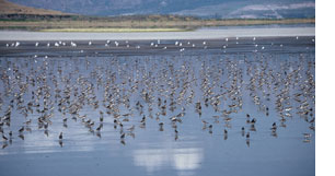 Shorelines, beaches and playas associated with saltwater are key in the uniqueness of the GSL ecosystem habitats, mostly due to their abundance of brine flies and near-shore populations of brine shrimp and corixid food. Shallow water, wind-drifted algae and shorelines provide a medium for significant brine fly pupae and adult concentrations. Brine flies forage on benthic algae, which are abundant and accessible near shorelines. As an example, a brine fly pupae survey of six miles of the Antelope Island Causeway accounted for 7,000,000,000 washed up brine fly pupae casings. During each summer and fall, millions of brine flies concentrate along the saltwater shorelines, within beach pools, and on nearby playas. These clouds of flies are important food for gulls and shorebirds. Adult brine shrimp and brine fly pupae are foraged from the nearby water edge by eared grebes, northern shovelers, common goldeneyes and phalaropes. Shorelines, beaches and playas associated with saltwater are key in the uniqueness of the GSL ecosystem habitats, mostly due to their abundance of brine flies and near-shore populations of brine shrimp and corixid food. Shallow water, wind-drifted algae and shorelines provide a medium for significant brine fly pupae and adult concentrations. Brine flies forage on benthic algae, which are abundant and accessible near shorelines. As an example, a brine fly pupae survey of six miles of the Antelope Island Causeway accounted for 7,000,000,000 washed up brine fly pupae casings. During each summer and fall, millions of brine flies concentrate along the saltwater shorelines, within beach pools, and on nearby playas. These clouds of flies are important food for gulls and shorebirds. Adult brine shrimp and brine fly pupae are foraged from the nearby water edge by eared grebes, northern shovelers, common goldeneyes and phalaropes.
|
Freshwater Shorelines
 Dikes, riverbanks and shorelines associated with wetlands and their distributaries are sites of freshwater invertebrate abundance. These systems are especially productive sites for midges. Waterfowl, marshland passerines, secretive marsh birds, herons and egrets forage and nest within and near these edges. Dikes, riverbanks and shorelines associated with wetlands and their distributaries are sites of freshwater invertebrate abundance. These systems are especially productive sites for midges. Waterfowl, marshland passerines, secretive marsh birds, herons and egrets forage and nest within and near these edges.
|
Saltwater-Freshwater Interface
 Essentially, this is where freshwater and saltwater mix. Usually the mixing comes from freshwater runoff, which feeds gravitationally into the GSL. In some ways this is similar to the effect that an estuary has within a maritime environment. A diversity of conditions and habitats bring about concentrations of birds. The major examples at the GSL are the out flow areas of the major river deltas; the greatest species diversity and concentration of birds are often found in these areas. Here two systems collide or intermingle, freshwater and saltwater invertebrates come together, fish concentrate or die, freshwater emigrants phase into halophytes. Crowfoot deltas form to provide vast regions of edge as freshwater trickles onto and into salt playas. At times tens of thousands of birds concentrate within this interface zone. Wherever fresh water flows into the GSL birds are found. During the late summer and fall large concentrations of California and Franklin’s gulls, black-necked stilts and American avocets occur at these sites. Essentially, this is where freshwater and saltwater mix. Usually the mixing comes from freshwater runoff, which feeds gravitationally into the GSL. In some ways this is similar to the effect that an estuary has within a maritime environment. A diversity of conditions and habitats bring about concentrations of birds. The major examples at the GSL are the out flow areas of the major river deltas; the greatest species diversity and concentration of birds are often found in these areas. Here two systems collide or intermingle, freshwater and saltwater invertebrates come together, fish concentrate or die, freshwater emigrants phase into halophytes. Crowfoot deltas form to provide vast regions of edge as freshwater trickles onto and into salt playas. At times tens of thousands of birds concentrate within this interface zone. Wherever fresh water flows into the GSL birds are found. During the late summer and fall large concentrations of California and Franklin’s gulls, black-necked stilts and American avocets occur at these sites.
|
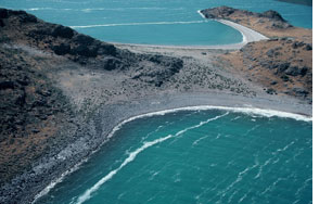
Rocky Shorelines and Levees
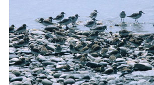 Many islands of the GSL have rocky shorelines, and there have been hundreds of miles of levees and dikes constructed around, along and across the lake. Most are constructed using riprap, road base and coble. These structures are used extensively as colonial nest sites by gulls. Canada geese also often use these structures for nesting. Killdeer nest here perhaps in larger numbers than anywhere else around the lake. The rocky portions of shoreline are used extensively by migrating sandpipers, especially sanderlings. Many islands of the GSL have rocky shorelines, and there have been hundreds of miles of levees and dikes constructed around, along and across the lake. Most are constructed using riprap, road base and coble. These structures are used extensively as colonial nest sites by gulls. Canada geese also often use these structures for nesting. Killdeer nest here perhaps in larger numbers than anywhere else around the lake. The rocky portions of shoreline are used extensively by migrating sandpipers, especially sanderlings.
|
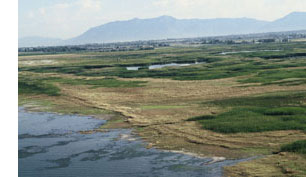
Freshwater Wetlands
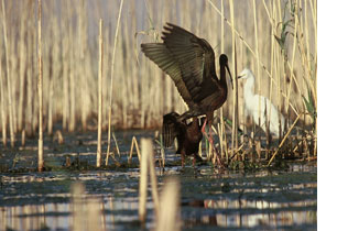 There are more than 400,000 acres of wetlands associated with the GSL, and most are located near the main river inflow deltas on the east, northeast and southeast parts of the lake. A significant portion of these wetlands is emergent, lacustrine systems that are administered as Wildlife Management Areas (WMA) by state, federal and private conservation organizations. When the GSL is relatively stable, between 4196-4200 ft ASL (above sea level) elevation for several years at a time, extensive wetlands form outside WMA impoundments. Freshwater wetlands provide the greatest single habitat and bird species diversity within the lake ecosystem. Millions of bird use days occur within these wetlands. Wetlands are especially important to nesting and migratory waterfowl, grebes, white-faced ibises, Franklin’s gulls, foraging pelicans and cormorants, rails and other secretive marsh birds, nesting and foraging terns, molting waterfowl, and many other birds. There are more than 400,000 acres of wetlands associated with the GSL, and most are located near the main river inflow deltas on the east, northeast and southeast parts of the lake. A significant portion of these wetlands is emergent, lacustrine systems that are administered as Wildlife Management Areas (WMA) by state, federal and private conservation organizations. When the GSL is relatively stable, between 4196-4200 ft ASL (above sea level) elevation for several years at a time, extensive wetlands form outside WMA impoundments. Freshwater wetlands provide the greatest single habitat and bird species diversity within the lake ecosystem. Millions of bird use days occur within these wetlands. Wetlands are especially important to nesting and migratory waterfowl, grebes, white-faced ibises, Franklin’s gulls, foraging pelicans and cormorants, rails and other secretive marsh birds, nesting and foraging terns, molting waterfowl, and many other birds.
|
Salt Marsh
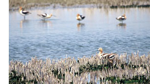 Salt marsh occurs at the GSL in the form of salt grass and pickleweed complexes. Other associated marsh plants are alkali bulrush and Olney three-square bulrush. These plant communities persist in more saline soils and are often located in closed water basins that lose water through evaporation. Many times they occur outside WMA management units or where seeps occur within playa complexes. Salt marshes are often the extension of the freshwater wetlands as the water chemistry grades from fresh to brackish to salty. The vegetation height is usually shorter than some freshwater plants (e.g., cattail). Salt marshes are used by avocets and stilts for nesting and are favorite cover for common snipe. Geese graze pickleweed in the winter. Salt marsh occurs at the GSL in the form of salt grass and pickleweed complexes. Other associated marsh plants are alkali bulrush and Olney three-square bulrush. These plant communities persist in more saline soils and are often located in closed water basins that lose water through evaporation. Many times they occur outside WMA management units or where seeps occur within playa complexes. Salt marshes are often the extension of the freshwater wetlands as the water chemistry grades from fresh to brackish to salty. The vegetation height is usually shorter than some freshwater plants (e.g., cattail). Salt marshes are used by avocets and stilts for nesting and are favorite cover for common snipe. Geese graze pickleweed in the winter.
|
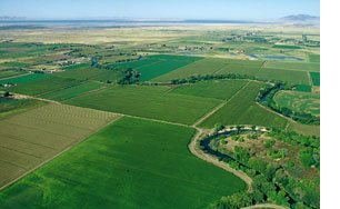
Lakeside Uplands
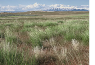 The uplands that border wetland complexes or that intermix with wetlands are key habitats for numerous aquatic bird species. They also act as buffers to wetlands from urban and agrarian communities. Many species of ducks nest in uplands sometimes significant distances from water. Two sandpipers nest and forage in uplands: the long-billed curlew and willet. A wetland that is buffered by upland is significantly more productive than one that borders an urban environment. The uplands that border wetland complexes or that intermix with wetlands are key habitats for numerous aquatic bird species. They also act as buffers to wetlands from urban and agrarian communities. Many species of ducks nest in uplands sometimes significant distances from water. Two sandpipers nest and forage in uplands: the long-billed curlew and willet. A wetland that is buffered by upland is significantly more productive than one that borders an urban environment.
|
Wet Meadow and Flooded Pastures
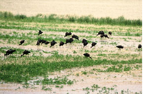 Many species forage in flood irrigated pastures. Flooding brings earthworms and other invertebrates to the surface where they are accessible to birds as food. They are especially important to white-faced ibises, Franklin’s gulls, and cattle egrets. Sometimes flocks of ibises will fly twenty or more miles to forage in pastures. Often ducks and geese utilize these man made and natural environments too. Sandhill cranes and common snipes nest and forage in these systems. Many species forage in flood irrigated pastures. Flooding brings earthworms and other invertebrates to the surface where they are accessible to birds as food. They are especially important to white-faced ibises, Franklin’s gulls, and cattle egrets. Sometimes flocks of ibises will fly twenty or more miles to forage in pastures. Often ducks and geese utilize these man made and natural environments too. Sandhill cranes and common snipes nest and forage in these systems.
|
Riparian Systems
 Riparian ribbons are the migratory pathways that attach the GSL ecosystem to the other habitats. They also provide nest and perching sites for many species of large aquatic birds including herons, egrets and cormorants. The near-lake riparian corridor is used by perching eagles in the winter. Riparian trees and gallery forest offer the only nearby vertical structure available to wetland birds. The lower structure of the riparian system is used by foraging black-crowned night herons and snowy egrets. Mid structure provides foraging perches for the belted kingfisher. The upper living branches and leaves are often foraging sites for spring and fall warblers, and the dead branches are used by flycatchers to hawk flying insects. Tree forks provide nesting habitat for red-tailed hawks, great horned owls, and great blue herons. As these trees die and fall down over waterways they become perching sites for ducks, cormorants and other birds. Riparian ribbons are the migratory pathways that attach the GSL ecosystem to the other habitats. They also provide nest and perching sites for many species of large aquatic birds including herons, egrets and cormorants. The near-lake riparian corridor is used by perching eagles in the winter. Riparian trees and gallery forest offer the only nearby vertical structure available to wetland birds. The lower structure of the riparian system is used by foraging black-crowned night herons and snowy egrets. Mid structure provides foraging perches for the belted kingfisher. The upper living branches and leaves are often foraging sites for spring and fall warblers, and the dead branches are used by flycatchers to hawk flying insects. Tree forks provide nesting habitat for red-tailed hawks, great horned owls, and great blue herons. As these trees die and fall down over waterways they become perching sites for ducks, cormorants and other birds.
|
Great Salt Lake Islands
 Nine islands on GSL have significant bird habitat values. These islands are Antelope, Hat, Carrington, Egg, Fremont, Gunnison, Landing Rocks, Stansbury, and White Rock. These habitat values change with lake volume and elevation. Most islands are accessible by land at low lake elevations, and conversely, are covered by water at high lake elevations. Consistent colonial nesting species of the island environments are California gulls, great blue herons, double-crested cormorants, American white pelicans, and Caspian terns. Even though they are not considered colonial nesting species, the Canada goose and some duck species nest within, or near, colonial nesting sites on some of the islands. Important populations of long-billed curlew nest on the larger islands. The islands of GSL provide other habitat values to birds in addition to nesting. For example, Gunnison Island was found to be used for foraging and resting by 110 different species between 1972 and 1974 (Knopf, 1975). Fremont and Antelope islands provide thermal and uplift draft for pelicans, assisting them in energy conservation as they travel to and from foraging locations. The peninsula of the Promontory Mountains, along with these two islands, are used by migrating raptors. Bars, mud flats, and hummocks are important substrates for colonial species for nesting, loafing, and foraging, although they are not islands. Nine islands on GSL have significant bird habitat values. These islands are Antelope, Hat, Carrington, Egg, Fremont, Gunnison, Landing Rocks, Stansbury, and White Rock. These habitat values change with lake volume and elevation. Most islands are accessible by land at low lake elevations, and conversely, are covered by water at high lake elevations. Consistent colonial nesting species of the island environments are California gulls, great blue herons, double-crested cormorants, American white pelicans, and Caspian terns. Even though they are not considered colonial nesting species, the Canada goose and some duck species nest within, or near, colonial nesting sites on some of the islands. Important populations of long-billed curlew nest on the larger islands. The islands of GSL provide other habitat values to birds in addition to nesting. For example, Gunnison Island was found to be used for foraging and resting by 110 different species between 1972 and 1974 (Knopf, 1975). Fremont and Antelope islands provide thermal and uplift draft for pelicans, assisting them in energy conservation as they travel to and from foraging locations. The peninsula of the Promontory Mountains, along with these two islands, are used by migrating raptors. Bars, mud flats, and hummocks are important substrates for colonial species for nesting, loafing, and foraging, although they are not islands.
|
|