Description
|
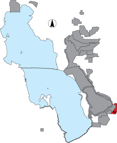
In this survey area we conducted a total count of all waterbird use areas visible from the following route. Travel south from Glover Lane and 650 West to dead end, return back to Glover Lane and Pipeline Road, and travel south along the Pipeline Road to Parrish Lane. This road parallels the railroad tracks on the west side. At Parrish Lane, travel east to 1250 West, then turn north and continue on to dead end pond. Return back to Pipeline Road and travel south to Porter Lane. Turn west at the landfill (some of this section will be residential and for travel purposes only). We surveyed upland drainages here, but not the large pond to the west and north. We turned west at 1600 North and continued along South Canal Road, bordering the South Bountiful Landfill to the large pond. The pond and associated wetlands were counted, and we returned back to the1600 North and 1100 West intersection and traveled north on 1100 West to 1200 North. Wetlands near the road leading west to the sewer plant were surveyed and we returned back to 1100 West and 1200 North and traveled south on 1100 West to 500 South, and then west to New State Duck Club road. We turned north at the gate on to berm to dead end while counting both sides of the berm road. There is public access. |