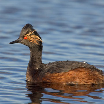
Eared Grebe (EAGR)

Primary Habitats

Salt Water  Fresh Water Saltwater Shorelines, Beaches and Playas Freshwater Shorelines Saltwater-Freshwater Interface Rocky Shorelines and Levees Freshwater Wetlands Salt Marsh Lakeside Uplands Wet Meadow & Flooded Pastures Riparian Systems Great Salt Lake Islands
X X X

Population Estimates
Great Salt Lake
Code
Global
North America
Mean
Aug-Sep
Peak
20-Aug
High Count
1997
Abundance Status
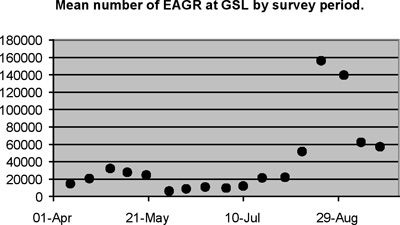
EAGR ~4,000,000 3,700,000 93,221 156,036 698,793 C
  

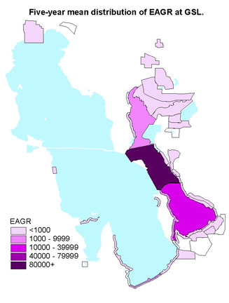
Click a survey area number on the map above or an area from the list below
to view the survey area data by year for this species.
1 - Timpie Springs WMA 2 - Stansbury Island North 3a - Stansbury Island South
3b - Stansbury Island South 5a - Interstate 80 North 5b - Interstate 80 North
6 - Saltair 7 - Associated Duck Club 8a - Kennecott
8c - Kennecott 9a - Audubon 9b - Audubon
9c - Audubon 10 - Crystal Lakeside 11 - Farmington Bay Lakeside
12 - Farmington Bay WMA 13 - West Farmington 14 - Antelope Island East
15 - Antelope Island West 16 - Antelope Island Causeway 17a - West Kaysville
17b - West Kaysville 18 - West Layton 19a - Howard Slough
19b - Howard Slough 19c - Howard Slough 20 - Ogden Bay WMA
21 - Ogden Bay Lakeside 22 - Ogden Bay North 23 - Rainbow
24 - South Harold 25 - Harold Crane WMA 27 - South Bear River
28 - Willard Spur 29 - Bear River Refuge 30 - Bear River Club
32 - Public Shooting Grounds WMA 33 - Salt Creek WMA 34a - East Promontory
34b - East Promontory 35 - Locomotive Springs WMA 36 - Salt Wells Flat WHA
37 - Bear River Bay 38 - Ogden Bay 39 - Farmington Bay
40 - Magcorp 41 - New State Duck Club 42 - East Farmington Bay
43 - Deardens Knoll 44 - Jordan River