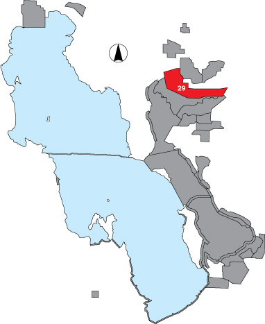
29 Bear River Refuge

Description

The area includes all impounded units and any appropriate habitat with established dike units, within the Bear River Bird Refuge. The area is managed by USFWS.

Primary Habitat

Salt Water  Fresh Water Saltwater Shorelines, Beaches and Playas Freshwater Shorelines Saltwater-Freshwater Interface Rocky Shorelines and Levees Freshwater Wetlands Salt Marsh Lakeside Uplands Wet Meadow & Flooded Pastures Riparian Systems Great Salt Lake Islands
X X

Area Size (ha)

10449.4

Estimated Area Covered by Survey (ha)

3134.8

Years Surveyed

5

Detection Rates

Due to emergent vegetation and viewing distances, visibility is considerably limited.

Site Bird Data

Species Mean Peak     Species Mean Peak
AGWT 32951.2 52584.7 GTBH 40.7 81.6
AMAV 13626.0 23240.0 KILL 5.0 14.3
AMCO 7560.4 10778.7 LBCU 0.1 1.0
AMWI 2148.6 2929.0 LBDO 1087.8 5580.3
AWPE 2119.2 3902.0 LESA 0.7 4.0
BASA 5.2 18.0 LESC 304.7 1271.0
BBPL 17.7 53.3 LEYE 5.5 62.4
BCNH 11.8 33.8 MAGO 8866.7 16956.5
BLTE 122.6 263.0 MALL 12256.8 18838.0
BNST 8351.8 14582.4 NOPI 14614.8 18840.0
BUFF 18.4 80.8 NSHO 12630.1 16674.2
BWTE 0.0 4.0 PBGR 12.0 25.0
CAEG 0.5 4.8 RBGU 22.3 868.8
CAGO 788.5 2874.3 REDH 643.9 1647.5
CAGU 1330.3 3569.0 RPHA 0.7 1600.0
CANV 26.9 119.3 RUDU 1116.0 2130.5
CATE 9.3 78.2 SACR 0.5 2.0
CITE 3609.1 5145.6 SAND 0.0 0.0
CLGR 1.3 20.8 SNEG 155.1 312.8
COGO 3.8 10.0 SNPL 0.0 0.8
DCCO 215.6 372.2 SPSA 2.4 7.6
EAGR 3.7 3932.0 WEGR 101.2 253.8
FOTE 70.3 201.0 WESA 11597.8 52396.0
FRGU 2806.7 9903.2 WFIB 8396.1 16006.8
GADW 9960.1 13450.0 WILL 16.0 60.5
GRYE 15.7 121.3 WIPH 5590.0 26541.8