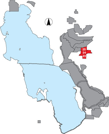
23 Rainbow • 24 South Harold • 25 Harold Crane WMA

Description

These three areas are adjacent to one another and have been typically surveyed as one route. All are managed by UDWR. The Rainbow site includes the George East Duck Club and Rainbow pond and is a total count survey from existing roads. South Harold Crane is also a total count within the gravel road through the UDWR gate on the east, the GSL Minerals Company canal on the north and west, and the railroad tracks on the south. Harold Crane WMA is a total count from all drivable interior dikes within the WMA.

Primary Habitat

Salt Water  Fresh Water Saltwater Shorelines, Beaches and Playas Freshwater Shorelines Saltwater-Freshwater Interface Rocky Shorelines and Levees Freshwater Wetlands Salt Marsh Lakeside Uplands Wet Meadow & Flooded Pastures Riparian Systems Great Salt Lake Islands
X X

Area Size (ha)

23 = 1799.7
24 = 1439.8
25 = 1773.4

Estimated Area Covered by Survey (ha)

23 = 593.9
24 = 475.1
25 = 585.2

Years Surveyed

4; area 25 surveyed all 5 years

Detection Rates

Some ponds are obstructed from view by tall emergent vegetation. By leaving the dike roads, all ponds could be accessed on foot for better viewing.

Description: These three areas are adjacent to one another and have been typically surveyed as one route. All are managed by UDWR. The Rainbow site includes the George East Duck Club and Rainbow pond and is a total count survey from existing roads. South Harold Crane is also a total count within the gravel road through the UDWR gate on the east, the GSL Minerals Company canal on the north and west, and the railroad tracks on the south. Harold Crane WMA is a total count from all drivable interior dikes within the WMA.

Site Bird Data (23)

Species Mean Peak     Species Mean Peak
AGWT 618.2 1261.7 GTBH 8.6 14.5
AMAV 239.7 580.0 KILL 3.3 9.0
AMCO 128.1 261.7 LBCU 3.9 6.0
AMWI 57.4 110.7 LBDO 38.2 100.0
AWPE 13.0 67.5 LESA 0.0 0.0
BASA 0.0 0.0 LESC 0.6 2.7
BBPL 0.0 0.0 LEYE 2.0 21.3
BCNH 2.6 8.0 MAGO 1.7 18.8
BLTE 0.0 0.0 MALL 400.1 558.3
BNST 87.4 202.8 NOPI 455.7 615.5
BUFF 0.0 0.0 NSHO 254.2 616.0
BWTE 0.0 6.0 PBGR 0.1 0.5
CAEG 0.4 1.5 RBGU 1.9 68.8
CAGO 117.4 287.8 REDH 19.9 62.3
CAGU 229.5 1021.7 RPHA 0.0 1.3
CANV 0.5 2.0 RUDU 7.0 16.3
CATE 0.4 4.3 SACR 2.7 9.0
CITE 74.9 127.3 SAND 0.0 0.0
CLGR 0.0 0.0 SNEG 24.1 81.3
COGO 0.0 0.0 SNPL 0.3 2.5
DCCO 0.6 2.0 SPSA 0.0 0.0
EAGR 0.0 4.8 WEGR 0.6 4.0
FOTE 8.2 23.3 WESA 0.0 0.0
FRGU 38.0 96.3 WFIB 478.8 720.5
GADW 116.5 172.5 WILL 3.3 12.3
GRYE 0.0 0.0 WIPH 12.3 40.3

Site Bird Data (24)

Species Mean Peak     Species Mean Peak
AGWT 960.2 1612.0 GTBH 6.7 12.5
AMAV 3029.9 4524.3 KILL 2.1 5.0
AMCO 254.2 1556.3 LBCU 2.5 5.3
AMWI 100.5 171.3 LBDO 105.6 304.5
AWPE 22.5 33.5 LESA 0.1 0.8
BASA 0.0 0.3 LESC 5.7 136.3
BBPL 0.6 1.3 LEYE 4.1 33.8
BCNH 3.3 10.5 MAGO 49.9 129.5
BLTE 0.0 0.0 MALL 683.1 1348.5
BNST 349.7 709.5 NOPI 544.9 909.5
BUFF 0.0 0.0 NSHO 297.5 612.5
BWTE 0.0 1.0 PBGR 0.2 0.5
CAEG 0.1 1.5 RBGU 19.7 57.0
CAGO 142.6 360.0 REDH 56.6 95.0
CAGU 127.9 211.7 RPHA 0.0 0.0
CANV 0.3 2.0 RUDU 2.3 21.5
CATE 0.3 3.0 SACR 9.3 24.5
CITE 234.1 393.8 SAND 0.0 0.0
CLGR 0.0 0.0 SNEG 16.7 46.5
COGO 0.0 0.0 SNPL 0.7 1.8
DCCO 3.6 16.0 SPSA 0.0 0.0
EAGR 0.6 38.0 WEGR 0.5 2.5
FOTE 17.9 43.3 WESA 0.0 0.0
FRGU 60.9 100.3 WFIB 392.2 577.8
GADW 231.6 431.5 WILL 4.3 10.5
GRYE 0.2 3.8 WIPH 32.4 66.7

Site Bird Data (25)

Species Mean Peak     Species Mean Peak
AGWT 2802.3 4406.6 GTBH 32.1 53.0
AMAV 1670.9 3088.0 KILL 5.7 10.8
AMCO 925.0 1514.6 LBCU 1.0 35.0
AMWI 369.1 1141.0 LBDO 1156.7 1797.6
AWPE 250.0 895.4 LESA 0.0 0.0
BASA 0.0 0.0 LESC 98.9 271.3
BBPL 9.9 47.5 LEYE 16.9 49.0
BCNH 35.7 72.0 MAGO 217.1 895.0
BLTE 0.2 34.8 MALL 2507.4 3354.4
BNST 803.5 1391.8 NOPI 2472.0 3927.2
BUFF 0.0 0.0 NSHO 1092.8 1570.4
BWTE 0.0 1.7 PBGR 1.0 2.8
CAEG 0.4 4.0 RBGU 27.4 37.8
CAGO 548.4 1419.8 REDH 342.6 586.8
CAGU 315.4 731.0 RPHA 0.0 1.2
CANV 8.5 40.3 RUDU 161.2 312.5
CATE 5.6 18.3 SACR 5.1 18.6
CITE 671.3 846.2 SAND 0.0 0.0
CLGR 0.0 0.0 SNEG 64.0 103.8
COGO 0.0 0.0 SNPL 0.5 2.3
DCCO 27.3 71.4 SPSA 0.0 0.5
EAGR 7.1 266.5 WEGR 10.6 30.4
FOTE 77.3 167.3 WESA 0.0 0.0
FRGU 328.8 809.6 WFIB 1520.2 2147.0
GADW 691.2 1205.6 WILL 7.9 13.2
GRYE 2.2 11.0 WIPH 314.4 676.2