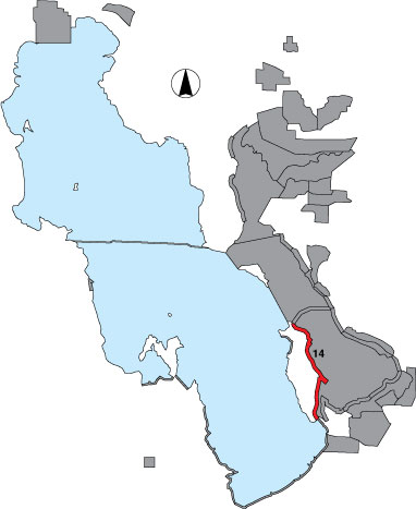
14 Antelope Island East

Description

The east side of Antelope Island State Park from the triangle intersection at the north causeway to the mainland gate at the south causeway is a total count.

Primary Habitat

Salt Water  Fresh Water Saltwater Shorelines, Beaches and Playas Freshwater Shorelines Saltwater-Freshwater Interface Rocky Shorelines and Levees Freshwater Wetlands Salt Marsh Lakeside Uplands Wet Meadow & Flooded Pastures Riparian Systems Great Salt Lake Islands
X X X X

Area Size (ha)

2417.1

Estimated Area Covered by Survey (ha)

2417.1

Years Surveyed

5

Detection Rates

The survey is conducted from the east side road, and in some places the viewing distance can compromise identification. Vegetation and land configuration also block viewing in many places.

Site Bird Data

Species Mean Peak     Species Mean Peak
AGWT 9.0 38.8 GTBH 0.4 2.0
AMAV 3078.9 8774.5 KILL 2.8 7.3
AMCO 0.1 0.7 LBCU 1.2 4.0
AMWI 0.0 2.0 LBDO 0.0 0.0
AWPE 0.0 7.5 LESA 0.0 0.0
BASA 0.0 0.0 LESC 1.3 5.0
BBPL 8.3 20.0 LEYE 0.0 0.0
BCNH 0.0 0.0 MAGO 0.2 0.8
BLTE 0.0 0.0 MALL 60.1 180.3
BNST 127.6 667.8 NOPI 5.2 21.5
BUFF 3.3 9.3 NSHO 120.0 461.2
BWTE 0.2 1.0 PBGR 0.0 0.0
CAEG 0.0 0.0 RBGU 0.0 51.0
CAGO 43.9 141.6 REDH 0.0 17.7
CAGU 855.6 3023.2 RPHA 0.0 62.5
CANV 0.3 1.3 RUDU 0.0 0.2
CATE 0.0 0.5 SACR 0.0 0.0
CITE 0.0 1.3 SAND 15.1 74.0
CLGR 0.0 0.0 SNEG 0.0 0.0
COGO 0.0 0.0 SNPL 0.0 0.3
DCCO 0.0 0.0 SPSA 0.0 0.0
EAGR 1238.1 1786.8 WEGR 0.5 6.0
FOTE 0.0 0.0 WESA 0.6 50.3
FRGU 676.7 1717.0 WFIB 0.0 5.0
GADW 37.6 188.0 WILL 11.7 57.5
GRYE 0.1 1.7 WIPH 54.9 166.0