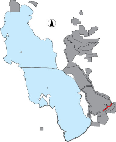
11 Farmington Bay Lakeside

Description

This is a ‘shoreline’ survey done from a WMA dike road. The stretch includes lakeside area from the southwest elbow of the Turpin dike to the Egg Island observation point, one randomly selected point sample and two drainage point samples. The point samples are semi-circles of ¼ mile radius and cut off by the dike. There is public access on UDWR managed site.

Primary Habitat

Salt Water  Fresh Water Saltwater Shorelines, Beaches and Playas Freshwater Shorelines Saltwater-Freshwater Interface Rocky Shorelines and Levees Freshwater Wetlands Salt Marsh Lakeside Uplands Wet Meadow & Flooded Pastures Riparian Systems Great Salt Lake Islands
X X

Area Size (ha)

522.2

Estimated Area Covered by Survey (ha)

522.2

Years Surveyed

5

Detection Rates

Visibility is clear.

Site Bird Data

Species Mean Peak     Species Mean Peak
AGWT 0.0 1.0 GTBH 1.6 8.2
AMAV 170.1 418.6 KILL 0.5 2.0
AMCO 23.2 94.3 LBCU 0.0 1.0
AMWI 0.0 0.0 LBDO 0.0 0.0
AWPE 21.8 87.0 LESA 0.0 5.0
BASA 0.0 0.0 LESC 0.0 3.0
BBPL 0.0 0.0 LEYE 0.0 0.0
BCNH 0.5 2.0 MAGO 2.0 11.0
BLTE 1.8 10.0 MALL 0.1 2.5
BNST 160.1 373.8 NOPI 0.4 1.8
BUFF 0.0 0.0 NSHO 376.7 638.4
BWTE 0.0 1.8 PBGR 0.1 0.4
CAEG 0.0 0.2 RBGU 38.1 178.6
CAGO 6.9 20.4 REDH 0.2 4.5
CAGU 154.9 404.6 RPHA 0.0 0.0
CANV 0.0 0.0 RUDU 0.8 29.0
CATE 0.9 4.5 SACR 0.0 0.0
CITE 0.0 8.5 SAND 0.0 1.6
CLGR 0.0 0.0 SNEG 8.2 37.6
COGO 0.0 0.0 SNPL 0.6 10.0
DCCO 1.4 10.6 SPSA 0.0 0.0
EAGR 65.3 436.4 WEGR 4.7 15.8
FOTE 5.0 22.0 WESA 1.1 3.8
FRGU 76.4 188.3 WFIB 19.2 57.0
GADW 0.2 5.8 WILL 4.8 44.0
GRYE 0.0 0.0 WIPH 3348.0 20086.0