9 Audubon

Description

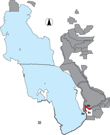
The Audubon site includes a shoreline survey from the Goggin Drain to the first major drainage of the Crystal Unit of Farmington Bay WMA, divided in two pieces by the old Antelope Island causeway. The southern portion (9a) was traveled by foot and included a randomly selected point sample. The northern portion (9b) was traveled by ATV and included a randomly selected point sample. The inland portion (9c) of the Audubon property includes several playas and a pond fed by canal water. An ephemeral pond called “Church Pond” was surveyed as an area count. Access is through Kennecott Inland Sea Shorebird Reserve and National Audubon Society private property.

Primary Habitat

Salt Water  Fresh Water Saltwater Shorelines, Beaches and Playas Freshwater Shorelines Saltwater-Freshwater Interface Rocky Shorelines and Levees Freshwater Wetlands Salt Marsh Lakeside Uplands Wet Meadow & Flooded Pastures Riparian Systems Great Salt Lake Islands
X X

Area Size (ha)

9a = 435.6
9b = 1092.4
9c = 3164.6

Estimated Area Covered by Survey (ha)

9a = 435.6
9b = 1092.4
9c = 791.2

Years Surveyed

5
(except 9c surveyed only in 2001)

Detection Rates

Visibility is good along the shoreline, although at some times mud consistencies prohibit travel at 100 yards from the water. Species identification may be difficult if viewing distances are too great.

Site Bird Data (9a)

Species Mean Peak     Species Mean Peak
AGWT 15.2 76.0 GTBH 0.3 1.0
AMAV 547.6 1424.5 KILL 0.9 2.3
AMCO 0.1 2.7 LBCU 3.0 9.3
AMWI 0.0 0.0 LBDO 0.1 0.8
AWPE 0.0 1.2 LESA 0.0 1.7
BASA 0.0 3.3 LESC 0.0 0.0
BBPL 61.4 164.3 LEYE 0.0 0.3
BCNH 0.2 3.0 MAGO 0.0 3.5
BLTE 0.0 0.0 MALL 0.1 2.8
BNST 6.0 37.8 NOPI 0.0 2.0
BUFF 0.0 0.0 NSHO 20.0 100.0
BWTE 0.0 0.5 PBGR 0.0 0.0
CAEG 0.0 0.3 RBGU 16.6 81.3
CAGO 7.2 39.8 REDH 0.0 0.0
CAGU 608.7 1376.3 RPHA 0.0 0.0
CANV 0.0 0.0 RUDU 0.0 0.0
CATE 0.1 1.0 SACR 0.0 0.8
CITE 0.4 4.0 SAND 17.4 53.0
CLGR 0.0 0.0 SNEG 0.1 0.5
COGO 0.0 0.0 SNPL 0.1 0.5
DCCO 1.4 5.3 SPSA 0.0 0.3
EAGR 0.0 62.5 WEGR 0.0 0.0
FOTE 0.0 0.0 WESA 3.1 16.7
FRGU 30.7 220.0 WFIB 0.5 15.0
GADW 3.4 11.0 WILL 6.1 19.0
GRYE 0.0 0.3 WIPH 14.8 65.0

Site Bird Data (9b)

Species Mean Peak     Species Mean Peak
AGWT 0.0 0.7 GTBH 0.3 1.8
AMAV 2253.3 7579.8 KILL 0.2 1.0
AMCO 0.0 0.0 LBCU 1.1 3.0
AMWI 0.5 2.4 LBDO 0.0 12.3
AWPE 0.0 24.0 LESA 1.3 7.8
BASA 8.8 48.0 LESC 0.0 0.0
BBPL 107.0 291.7 LEYE 0.1 1.4
BCNH 0.0 0.0 MAGO 0.4 4.7
BLTE 0.2 1.0 MALL 0.1 1.0
BNST 131.3 581.0 NOPI 1.5 4.6
BUFF 0.0 0.0 NSHO 170.5 306.8
BWTE 0.0 4.0 PBGR 0.0 0.0
CAEG 0.0 0.0 RBGU 146.0 511.5
CAGO 1.7 22.0 REDH 3.7 19.8
CAGU 304.8 1267.0 RPHA 4.6 18.3
CANV 0.0 0.0 RUDU 0.0 0.0
CATE 0.2 0.6 SACR 0.0 0.0
CITE 0.0 0.0 SAND 262.3 695.0
CLGR 0.0 0.0 SNEG 0.0 0.0
COGO 0.0 0.0 SNPL 34.3 97.2
DCCO 0.1 1.0 SPSA 0.0 0.3
EAGR 92.8 375.8 WEGR 0.0 0.0
FOTE 1.2 18.2 WESA 233.1 1217.5
FRGU 78.1 148.0 WFIB 0.1 0.7
GADW 4.1 20.0 WILL 9.4 35.0
GRYE 0.0 0.2 WIPH 37.1 177.5