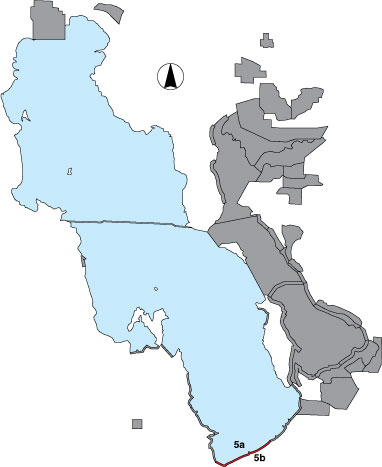
5 Interstate 80 North

Description

This area includes ponds between Interstate 80 and the railroad dike (5b) and a ‘shoreline like’ count along the railroad dike from Burmester to Black Rock (5a). The ponds were surveyed as a total count. The ‘shoreline’ was surveyed from the tracks counting out ¼ mile into the lake and included 2 randomly selected, semicircle point samples with ¼ mile radius cut off at the railroad. The access road is owned by Union Pacific Railroad.

Primary Habitat

Salt Water  Fresh Water Saltwater Shorelines, Beaches and Playas Freshwater Shorelines Saltwater-Freshwater Interface Rocky Shorelines and Levees Freshwater Wetlands Salt Marsh Lakeside Uplands Wet Meadow & Flooded Pastures Riparian Systems Great Salt Lake Islands
X X

Area Size (ha)

5a = 697.1
5b = 658.2

Estimated Area Covered by Survey (ha)

5a = 697.1
5b = 559.5

Years Surveyed

5

Detection Rates

Visibility is good for 5a. Viewing distances at the ponds of 5b made some waterfowl identification difficult even with a spotting scope.

Site Bird Data (5a)

Species Mean Peak     Species Mean Peak
AGWT 0.1 0.7 GTBH 0.8 3.3
AMAV 624.8 1729.2 KILL 42.3 568.8
AMCO 0.1 69.5 LBCU 0.0 1.4
AMWI 0.0 0.2 LBDO 0.0 0.0
AWPE 0.0 0.4 LESA 0.0 1.0
BASA 0.0 0.0 LESC 0.1 0.3
BBPL 0.0 0.0 LEYE 0.0 0.0
BCNH 0.0 0.3 MAGO 0.0 1.0
BLTE 0.0 0.0 MALL 0.1 13.0
BNST 9.4 38.0 NOPI 0.0 0.7
BUFF 0.0 0.0 NSHO 0.3 1.4
BWTE 0.0 4.2 PBGR 0.0 0.0
CAEG 0.0 0.3 RBGU 316.8 1455.0
CAGO 1.5 11.3 REDH 0.0 0.0
CAGU 12312.2 17710.3 RPHA 0.0 0.0
CANV 0.0 0.0 RUDU 0.0 0.0
CATE 0.1 1.0 SACR 0.0 0.0
CITE 0.0 0.0 SAND 2.1 8.3
CLGR 0.0 0.0 SNEG 0.0 0.0
COGO 0.3 1.7 SNPL 0.3 1.8
DCCO 0.0 0.0 SPSA 1.1 2.3
EAGR 2105.8 7063.8 WEGR 0.2 2.5
FOTE 0.2 1.8 WESA 0.0 5.8
FRGU 2302.4 6650.8 WFIB 0.8 4.6
GADW 0.0 5.3 WILL 16.3 23.4
GRYE 0.0 0.0 WIPH 5.3 18.6

Site Bird Data (5b)

Species Mean Peak     Species Mean Peak
AGWT 3.3 15.3 GTBH 1.8 3.7
AMAV 127.6 395.8 KILL 2.8 17.3
AMCO 37.4 150.3 LBCU 0.0 0.8
AMWI 5.9 21.8 LBDO 0.1 0.8
AWPE 95.5 141.3 LESA 0.0 0.0
BASA 0.0 0.0 LESC 0.0 0.0
BBPL 0.0 0.0 LEYE 0.1 1.2
BCNH 0.2 2.0 MAGO 0.4 2.6
BLTE 0.0 0.4 MALL 112.1 172.6
BNST 55.9 234.0 NOPI 140.2 467.2
BUFF 0.0 0.0 NSHO 8.1 36.0
BWTE 0.0 0.0 PBGR 0.7 1.4
CAEG 0.0 0.0 RBGU 6.2 30.0
CAGO 55.2 101.3 REDH 38.3 233.3
CAGU 9039.6 18914.8 RPHA 0.0 2.3
CANV 1.5 23.6 RUDU 0.5 2.3
CATE 0.5 4.3 SACR 0.0 0.0
CITE 2.0 5.4 SAND 1.0 5.0
CLGR 0.0 0.3 SNEG 12.8 35.2
COGO 0.0 0.0 SNPL 0.5 2.6
DCCO 3.2 11.3 SPSA 0.4 0.8
EAGR 0.7 249.3 WEGR 11.3 27.0
FOTE 21.3 300.0 WESA 1.2 4.8
FRGU 1744.0 4705.0 WFIB 20.5 67.3
GADW 29.3 100.5 WILL 5.4 18.2
GRYE 0.8 4.4 WIPH 17.4 61.2