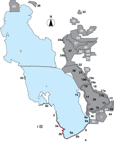
3 Stansbury Island South

Description

The stretch of mudflat between the pumping station on the south end of Stansbury Island to the railroad is a shoreline survey that has been divided into two sections by the secondary canal (3a = north section, 3b = south section). Each section has a randomly selected point sample and is managed by UDWR.

Primary Habitat

Salt Water  Fresh Water Saltwater Shorelines, Beaches and Playas Freshwater Shorelines Saltwater-Freshwater Interface Rocky Shorelines and Levees Freshwater Wetlands Salt Marsh Lakeside Uplands Wet Meadow & Flooded Pastures Riparian Systems Great Salt Lake Islands
X

Area Size (ha)

3a = 1003.5;
3b =722.3

Estimated Area Covered by Survey (ha)

3a = 1003.5;
3b =722.3

Years Surveyed

5

Detection Rates

Visibility is good, though at certain times mud consistencies may prohibit access to the shoreline by some distance, making detection and identification of small sandpipers and plovers difficult.

Site Bird Data (3a)

Species Mean Peak     Species Mean Peak
AGWT 0.0 0.0 GTBH 0.0 0.2
AMAV 4062.9 8039.8 KILL 0.1 1.0
AMCO 0.0 0.0 LBCU 1.2 10.6
AMWI 0.0 0.0 LBDO 28.4 170.2
AWPE 0.0 0.0 LESA 229.6 1290.0
BASA 53.2 217.8 LESC 0.0 0.0
BBPL 2.7 12.0 LEYE 0.3 5.4
BCNH 0.0 0.0 MAGO 1.3 7.6
BLTE 0.0 0.0 MALL 0.0 0.0
BNST 0.0 1.0 NOPI 0.0 0.0
BUFF 0.0 0.0 NSHO 0.0 0.5
BWTE 0.0 0.0 PBGR 0.0 0.0
CAEG 0.1 2.3 RBGU 2.8 14.0
CAGO 0.0 0.0 REDH 0.0 0.0
CAGU 2868.7 12430.4 RPHA 0.0 0.0
CANV 0.0 0.0 RUDU 0.0 0.0
CATE 0.0 0.0 SACR 0.0 0.0
CITE 0.0 0.0 SAND 0.0 0.6
CLGR 0.0 0.0 SNEG 0.0 0.0
COGO 0.0 0.0 SNPL 72.8 132.0
DCCO 0.0 0.0 SPSA 0.0 0.0
EAGR 170.5 846.5 WEGR 0.0 0.0
FOTE 0.0 0.0 WESA 1182.2 2821.4
FRGU 884.5 2343.8 WFIB 0.0 4.0
GADW 0.0 0.0 WILL 0.4 2.0
GRYE 0.0 0.0 WIPH 385.4 2280.4

Site Bird Data (3b)

Species Mean Peak     Species Mean Peak
AGWT 0.0 0.0 GTBH 0.0 0.4
AMAV 1166.9 1930.8 KILL 0.5 2.5
AMCO 0.0 0.0 LBCU 0.8 4.0
AMWI 0.0 0.0 LBDO 0.0 0.0
AWPE 0.1 0.4 LESA 0.0 1.0
BASA 0.7 4.0 LESC 0.0 0.0
BBPL 0.0 0.0 LEYE 0.0 0.0
BCNH 0.0 0.0 MAGO 0.0 2.0
BLTE 0.0 0.0 MALL 0.0 0.8
BNST 1.1 3.0 NOPI 0.0 0.0
BUFF 0.0 0.0 NSHO 0.0 0.0
BWTE 0.0 0.0 PBGR 0.0 0.0
CAEG 0.0 0.0 RBGU 0.0 0.0
CAGO 0.0 0.5 REDH 0.0 0.0
CAGU 992.6 2448.8 RPHA 0.0 0.0
CANV 0.0 0.5 RUDU 0.0 0.0
CATE 0.0 0.0 SACR 0.0 0.0
CITE 0.0 0.0 SAND 0.0 13.0
CLGR 0.0 0.0 SNEG 0.0 0.0
COGO 0.0 0.0 SNPL 38.3 96.2
DCCO 0.0 0.0 SPSA 0.0 0.0
EAGR 0.0 13.3 WEGR 0.0 0.0
FOTE 0.0 0.0 WESA 176.0 693.4
FRGU 2067.8 4181.8 WFIB 0.0 0.5
GADW 0.0 0.4 WILL 3.1 11.8
GRYE 0.0 0.0 WIPH 56.3 827.4