 |
 |
 |
||||||||||||
 |
 |
 |
 |
 |
 |
 |
 |
|||||||
Total Count Surveys
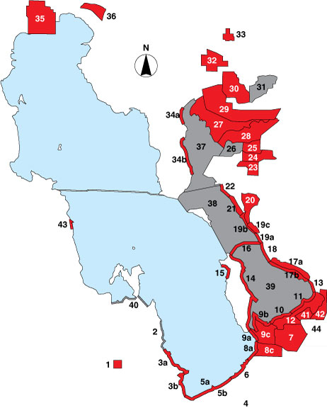
Highlight survey areas by survey methods by clicking on one of the following:
TOTAL COUNT • POINT SAMPLE • AREA COUNT • AERIAL SURVEY
(clicking on the survey method below will display an explanation of survey methodology)
|
Area #
|
Area Name
|
Years Surveyed
|
Survey Technique*
|
Mode of Travel
|
Site Description
|
|
1
|
Timpie Springs WMA
|
1997-2001
|
Driving
|
State managed wetland
|
|
|
2
|
Stansbury Island North
|
1999-2001
|
Airplane
|
Private Shoreline
|
|
|
3a
|
Stansbury Island South- N
|
1997-2001
|
ATV/walking
|
Shoreline
|
|
|
3b
|
Stansbury Island South- S
|
1997-2001
|
ATV/walking
|
Shoreline
|
|
|
4
|
Interstate 80 South
|
Not surveyed
|
|
|
|
|
5a
|
I-80 North-N
|
1997-2001
|
Driving
|
Shoreline
|
|
|
5b
|
I-80 North- S
|
1997-2001
|
Driving
|
Wetland-flooded area
|
|
|
6
|
Saltair
|
1997-2001
|
Walking
|
Shoreline
|
|
|
7
|
Associated Duck Club
|
1997-2001
|
Driving/walking
|
Private duck club
|
|
|
8a
|
Kennecott- Lakeside
|
1997-2001
|
Walking
|
Shoreline
|
|
|
8c
|
Kennecott- ISSR
|
1997-2001
|
Walking
|
Privately managed wetland
|
|
|
9a
|
Audubon Lakeside
|
1997-2001
|
ATV/walking
|
Shoreline
|
|
|
9b
|
Audubon North
|
1997-2001
|
ATV/walking
|
Shoreline
|
|
|
9c
|
Audubon Interior
|
2001
|
ATV/walking
|
Privately managed wetland
|
|
|
10
|
Crystal Lakeside
|
1997-2001
|
Airboat
|
Marsh
|
|
|
11
|
Farmington Bay Lakeside
|
1997-2001
|
Driving
|
Shoreline
|
|
|
12
|
Farmington Bay WMA
|
1997-2001
|
Driving
|
State managed wetland
|
|
|
13
|
West Farmington
|
1997-2001
|
Walking
|
Shoreline
|
|
|
14
|
Antelope Island East
|
1997-2001
|
Driving
|
Island shoreline
|
|
|
15
|
Antelope Island West
|
1997-2001
|
Walking
|
Island shoreline
|
|
|
16
|
Antelope Island Causeway
|
1997-2001
|
Driving
|
Road to island
|
|
|
17a
|
West Kaysville- Interior
|
1997-2001
|
Airboat
|
Marsh
|
|
|
17b
|
West Kaysville- Shore
|
1997-2001
|
ATV/walking/airboat
|
Shoreline
|
|
|
18
|
West Layton
|
1997-2001
|
Walking
|
Shoreline
|
|
|
19a
|
Howard Slough WMA- Shore
|
1997-2001
|
Walking
|
Shoreline
|
|
|
19b
|
Howard Slough WMA- Dike
|
1997-2001
|
Driving
|
Diked shoreline
|
|
|
19c
|
Howard Slough WMA- Pond
|
1997-2001
|
Driving/walking
|
State managed wetland
|
|
|
20
|
Ogden Bay WMA
|
1997-2001
|
Driving
|
State managed wetland
|
|
|
21
|
Ogden Bay Lakeside
|
1997-2001
|
Airboat
|
Marsh
|
|
|
22
|
Ogden Bay North
|
1998-2001
|
Airboat
|
Shoreline
|
|
|
23
|
Rainbow
|
1998-2001
|
Driving
|
Private duck club
|
|
|
24
|
South Harold Crane
|
1998-2001
|
Driving
|
State managed wetland
|
|
|
25
|
Harold Crane WMA
|
1997-2001
|
Driving
|
State managed wetland
|
|
|
26
|
West Harold Crane Mud Bar
|
Not surveyed
|
|
|
|
|
27
|
South Bear River
|
1997-2001
|
Airboat
|
Federal managed wetland
|
|
|
28
|
Willard Spur
|
1997-2001
|
Airboat/airplane
|
Federal managed wetland
|
|
|
29
|
Bear River Refuge
|
1997-2001
|
Driving
|
Federal managed wetland
|
|
|
30
|
Bear River Club
|
1997-2001
|
Driving/walking
|
Private duck club
|
|
|
31
|
Chesapeake
|
Not surveyed
|
|
|
|
|
32
|
Public Shooting Grounds WMA
|
1997-2001
|
Driving
|
State managed wetland
|
|
|
33
|
Salt Creek WMA
|
1997-2001
|
Driving
|
State managed wetland
|
|
|
34a
|
East Promontory- N
|
1997-2001
|
Walking
|
Shoreline
|
|
|
34b
|
East Promontory- S
|
1997-2001
|
Driving
|
Shoreline
|
|
|
35
|
Locomotive Springs WMA
|
1997, 2001
|
Driving
|
State managed wetland
|
|
|
36
|
Salt Wells Flat WHA
|
1997-2001
|
ATV/walking
|
Federal shoreline, wetland, and mudflat
|
|
|
37
|
Bear River Bay
|
1997-2001
|
Airplane
|
Open water
|
|
|
38
|
Ogden Bay
|
1997-2001
|
Airplane
|
Open water
|
|
|
39
|
Farmington Bay
|
1997-2001
|
Airplane
|
Open water
|
|
|
40
|
Magcorp
|
1998-2001
|
Driving
|
Two lakeside ponds
|
|
|
41
|
New State Duck Club
|
1999, 2001
|
Motorized boat
|
Private duck club
|
|
|
42
|
East Farmington Bay
|
1999-2001
|
Driving
|
Agricultural, urban, and industrial lands
|
|
|
43
|
Deardens Knoll
|
1999-2001
|
Driving
|
US Airforce/BLM public land
|
|
|
44
|
Jordan River
|
1999-2000
|
Airplane
|
Private agricultural land
|
AC = Area Count; AR = Aerial Survey